5:53 PM Thursday, May 2, 2024
- Tonight, expect areas of fog accompanied by light rain and drizzle.
- The fog and low clouds will dissipate by early to mid-morning on Friday, leading to some expected sunshine in the afternoon.
- Expect breezy northeast winds near Lake Superior, with gusts reaching up to 30 mph tonight. The winds will shift to the southwest and continue to be gusty on Friday, with speeds ranging from 15 to 30 mph.
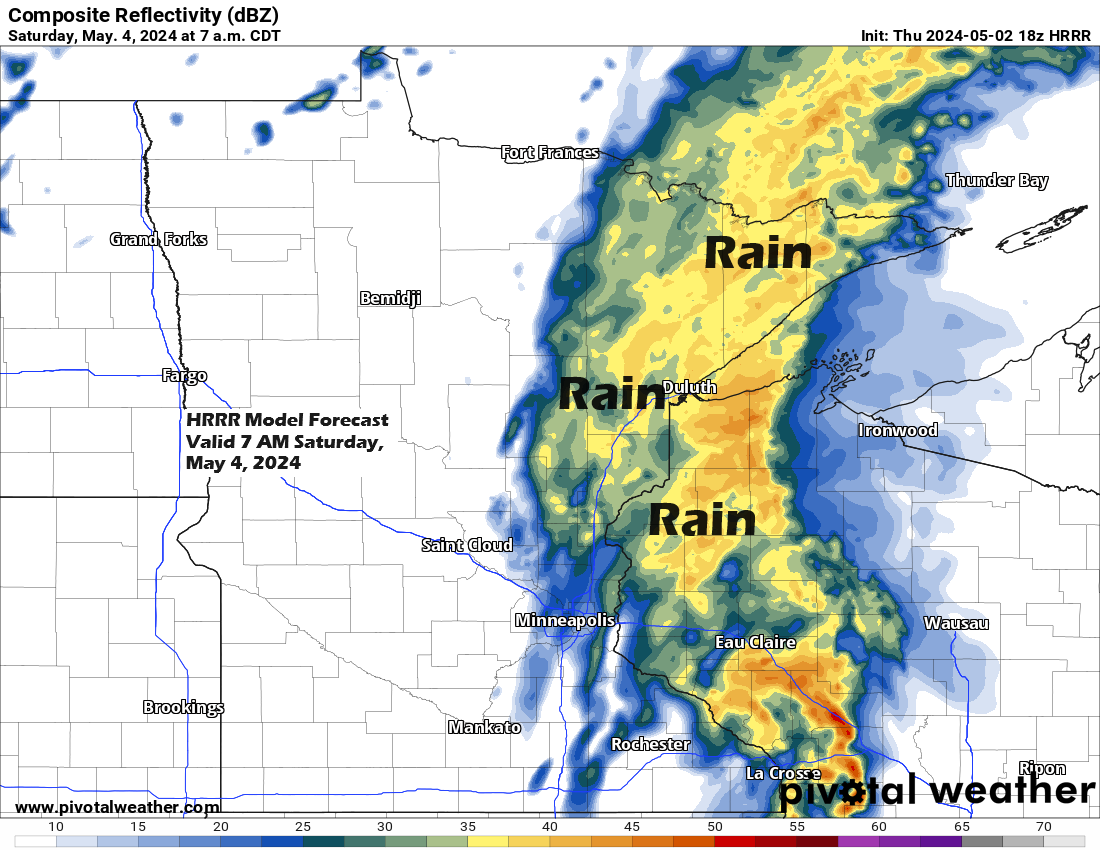
- Expect another bout of light to moderate rain late Friday night into Saturday morning; however, the remainder of the weekend is anticipated to be mostly dry.
- A slow-moving system may result in several days of intermittent showers next week.
Additional rainfall ranging from approximately 0.05 inches to 0.40 inches is expected across the Northland region through Saturday afternoon.

Observing the upper-level pattern reveals an upper trough spanning the northern Rockies, northern Plains, and extending into western Canada, while a ridge is present over the eastern U.S.
Goes-16 water vapor loop ending 5:30 PM CT Thursday, May 2, 2024.

Today, under the upper ridge, temperatures are quite high, reaching into the 80s and even some 90s in the southeastern/eastern U.S., with the deep south experiencing even more intense heat.

The majority of showers tonight are expected to occur over north central and northeast Minnesota.
NAM 3km model simulated radar forecast through 7 AM Friday.

The forecast for Friday indicates a predominantly dry day, but there’s a chance of rain moving northeastward across the region late at night, continuing into early Saturday morning. This rainfall is expected to clear eastward by mid to late Saturday morning, with the possibility of a few isolated showers in the afternoon.
NAM 3km model simulated radar forecast valid 7 PM Friday to 7 PM Saturday.

Much of the Northland experienced a return to cooler temperatures today, owing to a fresh bout of rain, drizzle, and cloudy skies.
This afternoon, temperatures in Duluth were between 10 to nearly 20 degrees cooler than those of Wednesday afternoon.

This is a snapshot of temperatures from late Thursday afternoon alongside the typical high for May 2nd.
Brainerd: 49, normal high 63
Ashland: 46, normal high 59
International Falls: 50, normal high 58
Hibbing: 45, normal high 58
Duluth: 45, normal high 57

Milder temperatures are expected on Friday, which will be accompanied by gusty southwesterly winds.
It appears that Duluth will finally see temperatures returning to the low, and possibly even mid, 60s on Friday. The last time Duluth experienced temperatures of 60 or higher was on April 22nd, with a high of 65.

The upcoming week is expected to present a more pronounced weather pattern, characterized by an upper-level low across the northern Plains and a ridge over central Canada.
The presence of a ridge in northern Canada is expected to cause the upper low over the northern Plains to progress eastward at a slow pace next week.
The amount of rain and the number of rainy days in the Northland next week will hinge on the trajectory of the low over the northern Plains. However, we can anticipate some chances of rain from next Monday night through Tuesday, and possibly extending to next Thursday or even Friday.

Thanks for reading!
Tim
Leave a Reply