6:34 PM Saturday, June 22, 2024
An active weather pattern continues.
Rain is expected this evening, with a few showers and isolated thunderstorms to follow on Sunday.
The forecast for Monday indicates dry conditions during the day, but by nightfall, there is a possibility of isolated to scattered, strong to severe thunderstorms due to a low-pressure system with its associated warm and cold fronts moving across the Upper Midwest.
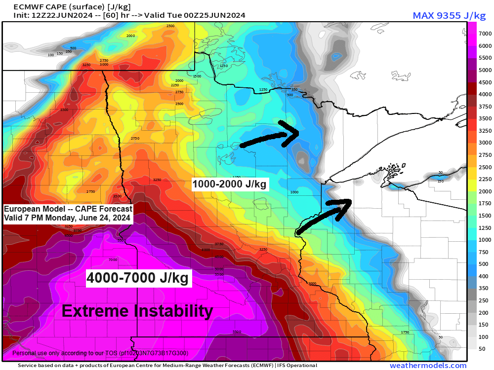
Preliminary forecasts suggest significant instability (5000+ J/kg CAPE) over eastern South Dakota and southwest Minnesota on Monday afternoon, with some of this instability expected to extend northeast into the Northland by late Monday afternoon and into the night.
If sufficient forcing occurs to break through the cap (warm temperatures aloft), we may witness isolated to scattered thunderstorms, ranging from strong to severe, developing late Monday afternoon or during the night. The primary hazards from these storms are likely to be damaging winds and large hail.
Currently, there is a Slight Risk, or level 2 out of 5, for severe thunderstorms across all of northeast Minnesota and northwest Wisconsin from late Monday afternoon into Monday night.

The 700mb temperatures are expected to be quite warm, ranging from about +12 to +14C on Monday. This warmth could inhibit the development of numerous thunderstorms with the system arriving on Monday.

Today’s rainfall pattern was quite erratic, with some decent rain totals recorded along the South Shore of Lake Superior in northwest Wisconsin, extending westward towards the Duluth area. Additionally, elevated rain totals were observed in parts of north central Minnesota around the Brainerd Lakes area.
As of 5 PM today, the highest recorded rainfall totals were 0.69 inches in Ashland, WI, followed by 0.42 inches in Poplar, WI. Duluth Sky Harbor Airport reported 0.34 inches of rainfall this morning.

24-Hour Rainfall Reports from June 21-22, 2024, as of 5:06 PM on the 22nd
Source: MesoWest
Ashland, WI: 0.69″
Poplar, WI: 0.42″
Duluth Sky Harbor Airport: 0.34″
Superior Airport: 0.28″
Solon Springs, WI: 0.28″
Esko, MN: 0.28″
Washburn, WI: 0.28″
Cable, WI: 0.19″
Brainerd, MN: 0.17″
Winter, WI: 0.13″
Glidden, WI: 0.10″
Hermantown, MN: 0.10″
Hill City, MN: 0.08″
Duluth Airport: 0.06″
Clam Lake, WI: 0.06″
Walker, MN: 0.05″
McGregor, MN: 0.03″
Moose Lake, MN: 0.02″
Grand Rapids, MN: 0.02″
Bigfork, MN: 0.02″
Siren, WI: 0.01″
Saginaw, MN: 0.01″
Hayward, WI: 0.01″
Danbury, WI: 0.01″
Northome, MN: 0.01″
A fairly strong trough is advancing eastward across the region this afternoon, though the system is progressing quite rapidly.

Quite an impressive system passing through the upper Midwest today.
Goes-16 water vapor loop from Saturday, June 22, 2024, loop time ends 6:10 PM CT.

A band of light rain, marked by heavier bursts where the radar shows yellow, is tracking eastward across parts of the Northland this afternoon. The rain is expected to taper off from west to east by later this evening.
Radar loop ends 5:26 PM Saturday, June 22, 2024.
NAM 3km model simulated radar forecast through 7 PM Sunday.

The computer models have faced significant challenges with this weather pattern recently. However, the main takeaway is that widespread rain is expected this evening, with isolated showers forecasted for Sunday. Should you find yourself under one of these showers, anticipate a brief but intense downpour on Sunday.
Here’s a look at the NWS Blend of Models total rainfall through 7 PM Sunday.

Flood Warnings remain in effect in parts of northeast Minnesota.
Note: A new flood warning has been issued today for the St. Louis River at Scanlon, which will remain in effect until Monday afternoon. Minor flooding is expected adjacent to the river near Cloquet city park and near Scanlon.

Thanks for reading!
Tim
Leave a Reply