6:47 PM Tuesday, June 25, 2024
Generally, the active weather pattern we’ve experienced for weeks shows little sign of changing in the near future.
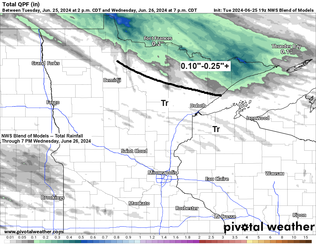
An incoming cold front and an upper-level wave are expected to move southeast across the Northland tonight. This system is anticipated to bring rain showers primarily to northern Minnesota both late tonight and Wednesday. Additionally, a few showers may extend southward into the Twin Ports area on Wednesday.
Rain is expected to return to the Northland on Friday, with the possibility of it starting as early as Thursday night. Showers may continue into Saturday especially in northern Minnesota. The weather is likely to clear up by Sunday, followed by another opportunity for rain on Monday or Monday night.
Radar imagery indicates rain north of the border late this afternoon, with some of this precipitation expected to move southward and eastward, impacting areas of northern Minnesota later tonight. Some showers may persist into Wednesday.
Radar loop from Tuesday, June 25, 2024, loop time ends 6:18 PM CT.
NAM model 500mb forecast through 7 AM Wednesday.

A significantly stronger system is predicted to move northeast from the northern Plains on Friday. This system is expected to bring another round of rain to northeast Minnesota and northwest Wisconsin, with the heaviest rainfall, potentially nearing an inch, anticipated in northern Minnesota. Lesser amounts are expected further south, including the Twin Ports area, according to current forecasts.
Showers may persist into Saturday, with the highest likelihood of occurrence in northern Minnesota.

Flood Warnings remain in effect for parts of the Northland.

Duluth experienced a rare warm day with temperatures in the 80s. In fact, the high of 84 degrees today is not only the warmest of the year so far but also signifies the second instance this month that the temperature has reached 80 degrees or more.
Expect cooler temperatures in the coming days, with highs ranging from the 60s to the lower 70s on Wednesday—cooler near Lake Superior. Similar conditions with 60s and 70s are anticipated for Thursday and Friday, but a northeast wind may result in even cooler temperatures near Lake Superior on both days.

It’s always intriguing to observe how the direction of the wind affects temperatures around Lake Superior.
On Monday, a northeast wind resulted in significantly cooler temperatures near Lake Superior, while other regions in Minnesota experienced very warm to hot conditions. However, today witnessed a reversal, with a west wind bringing much warmer temperatures to the Lake Superior area, in contrast to the rest of Minnesota, which saw slightly cooler temperatures this afternoon compared to those of Monday afternoon.

Thanks for reading!
Tim
Leave a Reply