5:53 PM Wednesday, June 26, 2024
Over the next five days, it seems that Sunday will be the sole day without rain, while a significant portion of Thursday is also expected to remain dry.
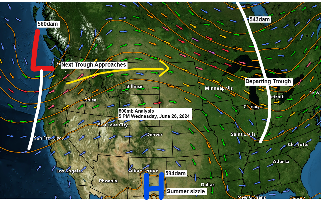
A low-pressure system, accompanied by its warm and cold fronts, will shift eastward from the northern Rockies and Plains in the coming days. This system is expected to traverse the upper Midwest by Friday, with residual effects possibly extending into Saturday.
Widespread rain is anticipated across northeast Minnesota and northwest Wisconsin, starting Thursday night and persisting into Friday morning. It is expected to taper off to scattered showers by Friday afternoon and evening.
There may also be scattered showers on Saturday.
Note: Widespread thunderstorms appear unlikely with the upcoming late-week system, though a few thunderstorms may occur. However, severe weather is not anticipated for Friday or Saturday the way it looks now.
Duluth has experienced seven days without rain this month, while the remaining days have seen at least a trace. The month of June may conclude with either eight or nine dry days, contingent on the weather this coming Thursday and Sunday.
It’s worth mentioning that our run of dry Fridays this month is expected to come to an end this upcoming Friday.

Updated rainfall totals for June 2024, as of 4 PM on the 26th.
Note: The record for the wettest June in Ashland is 8.97 inches, established in 2018.
Ashland, WI
Total: 7.79″
Departure: +4.37″ above normal
Duluth, MN
Total: 6.23″
Departure: +2.51″ above normal
Hibbing, MN
Total: 5.80″
Departure: +2.11″ above normal
Brainerd, MN
Total: 5.12″
Departure: +1.71″ above normal
International Falls, MN
Total: 2.78″
Departure: -0.45″ below normal
Most areas of northeast Minnesota are forecasted to receive between half an inch and an inch or more of rain from Thursday night through Saturday, with the bulk of the rainfall expected between Thursday night and Friday afternoon.
Current forecasts indicate that northwest Wisconsin can expect between a quarter and a half-inch of rain or possibly more.

Rainfall is anticipated to move eastward into the Northland area on Thursday evening, continuing overnight.
NAM 3km model simulated radar forecast valid 7 PM Thursday to 7 PM Friday.

As we move into early next week, we’re expecting another weather system, quite similar to the one we experienced on Friday. This system is anticipated to bring additional rainfall to northeast Minnesota and northwest Wisconsin from Monday afternoon into the evening.
The arrival time of the next system in Duluth may shift over the coming days; however, current predictions suggest that rain will start early Monday evening, between 6 and 8 PM.
European model simulated radar forecast valid from 7 AM Monday to 7 AM Tuesday.

The July forecast from the CFS model indicates an unfavorable outlook for the upper Midwest, with rainfall expected to be above average, as depicted by the green colors in the loop below.
Note: The average rainfall in Duluth in July is 3.93 inches. Wettest July on record is 10.83 inches set in 1909.
Here are the latest seven precipitation anomaly forecasts for July 2024 according to the CFS model.

Early Wednesday morning, the far northern region of Minnesota, extending into the Arrowhead, experienced additional rainfall, with a few areas recording about half an inch or more.

Rainfall Reports from Wednesday, June 26, 2024
Source: MesoWest
Bay of Grand Marais, MN: 0.76″
Winton, MN: 0.48″
Littlefork, MN: 0.42″
Isabella, MN: 0.23″
Orr, MN: 0.14″
International Falls, MN: 0.12″
Northome, MN: 0.11″
Ely, MN: 0.09″
Schroeder, MN: 0.08″
Hermantown, MN: 0.04″
Duluth Airport: 0.02″
As the year progresses, the northeast wind sweeping across Lake Superior begins to lose its chill, a sign that the lake’s waters are gradually warming in anticipation of summer.
As of June 26th, water temperatures in Lake Superior are primarily in the 50s, with regions near the shore nearing 60 degrees.

The water surface temperature of Lake Superior is consistent with the average temperatures observed in late June, based on climate data from 1995 to 2023.

Thanks for reading!
Tim
Leave a Reply