5:37 PM Sunday, July 7, 2024
The northern Plains and upper Midwest have experienced another day of scattered showers and thunderstorms due to several disturbances moving through the region.
Anticipate comparable weather conditions on Monday and Tuesday, with possibilities for isolated to scattered showers and thunderstorms across northeast Minnesota and northwest Wisconsin. However, as observed in the past few days, there will be numerous dry periods interspersed, and not everyone is expected to experience rainfall in the coming days.
For the next few days, temperatures are expected to stay close to seasonal averages, with highs ranging from the mid-70s to the low 80s. However, later this week, we may see a rise above the usual temperatures, with highs reaching well into the 80s, accompanied by muggy conditions and dew points in the 60s—a typical summer scenario.
Radar loop ends 5:22 PM Sunday, July 7, 2024.
Goes-16 water vapor loop ending 4:10 PM CT Sunday, July 7, 2024.

Scattered showers are expected to cease by later this evening, with areas of fog developing afterward. The pattern will repeat on Monday, with showers likely to emerge across the region, particularly during the afternoon and evening.
NAM 3km model simulated radar forecast through 7 PM Monday.


Today, the western and southwestern U.S. are experiencing widespread, intense heat with temperatures reaching 100 degrees or higher. Even southern British Columbia, Canada, is seeing temperatures in the 90s this afternoon.

For the next two weeks, a persistent northwest flow aloft is expected across the Northland, while an upper-level ridge dominates the southwest U.S.


The persistent northwest flow aloft will help confine the hottest temperatures and most intense heat to areas west and south of the Northland. However, we are still anticipating above-average temperatures in our region this week and next, which could result in several days with highs in the 80s.
Typically, Duluth experiences 11 days in July with temperatures reaching at least 80 degrees. This July, there have been two days with temperatures at or above 80 degrees.


The average surface water temperature of Lake Superior is currently a bit below the usual for early July, averaging around 48 degrees, whereas it typically averages around 50 degrees during this time.

The head of Lake Superior, or the southwest arm of the lake, is one of the warmer areas, with water temperatures ranging from the 60s to around 70 degrees near the shoreline.

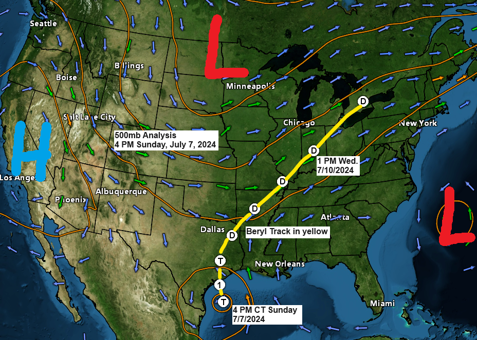
Beryl Information — 4 PM Sunday, July 7, 2024.
- Location about 130 miles south-southeast of Matagorda, Texas or about 135 miles east-southeast of Corpus Christi, Texas
- Maximum Sustained Winds: 65 mph
- Present Movement: NNW at 12 mph
- Minimum Central Pressure: 988mb/29.18 inches
There is a danger of life-threatening storm surge inundation along the coast of Texas from the north entrance to the Padre Island National Seashore to Sabine Pass, including Matagorda Bay and Galveston Bay.
Beryl is forecast to bring damaging hurricane force winds to portions of the Texas coast tonight and early Monday.

Radar animation of Tropical Storm Beryl concluding at 5:04 PM CT, Sunday, July 7, 2024.
Goes-16 satellite imagery of tropical storm Beryl.
Loop time ends 5:07 PM CT, Sunday, July 7, 2024.

Loop time ends 5:07 PM CT, Sunday, July 7, 2024.

Peak Storm Surge Forecast

Rainfall Potential through 7 PM Wednesday, July 10, 2024.

Thanks for reading!
Tim
Leave a Reply