1:48 PM Sunday, July 7, 2024
Local Storm Reports for July 6, 2024
Source: National Weather Service, Duluth, Minnesota
- 5:05 PM: Hail 0.75 inch. 3 W Lester Park, MN (St. Louis County)
- 5:07 PM: Hail 0.75 inch. 2 W Lester Park, MN (St. Louis County)
- 6:33 PM: Flood. 3 WSW South Range, WI (Douglas County) Report of 1-5 inches of water over Hendrickson Road.
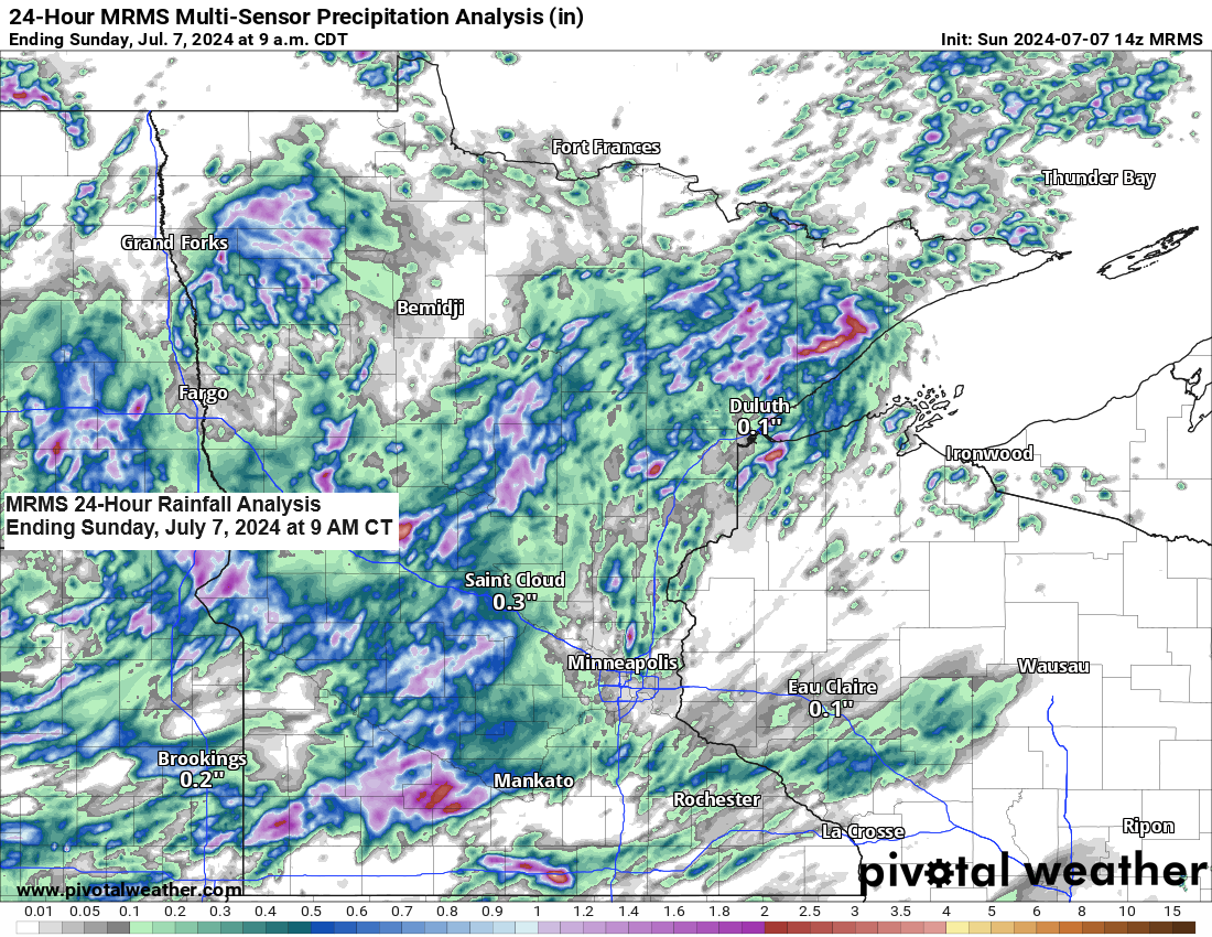
Additional showers and thunderstorms emerged in the Northland on Saturday afternoon, continuing into the early evening. These storms brought heavy rainfall, with several areas receiving between a half-inch and an inch or more of rain during the late afternoon to early evening period.

The South Range area in Douglas County in northwest Wisconsin, was among the areas most affected, with radar estimates indicating that between 2 to 4 inches of rain fell there on Saturday afternoon.

Numerous other pockets of heavier rainfall, totaling around a half inch to an inch or more, were recorded on Saturday afternoon and evening, as indicated by the blue and purple colors in the image below.

24-Hour Rainfall Reports for July 6-7, 2024, as of 1:16 PM on the 7th
Source: MesoWest
Isabella, MN: 1.30″
Brainerd, MN: 0.93″
International Falls, MN: 0.77″
Orr, MN: 0.75″
Walker, MN: 0.55″
Keewatin, MN: 0.54″
Schroeder, MN: 0.45″
Moose Lake, MN: 0.35″
Hibbing, MN: 0.31″
Bay of Grand Marais, MN: 0.29″
Winton, MN: 0.28″
Eveleth, MN: 0.28″
Ely, MN: 0.26″
Hill City, MN: 0.24″
Hayward, WI: 0.24″
Cable, WI: 0.24″
Saginaw, MN: 0.23″
Nashwauk, MN: 0.22″
Poplar, WI: 0.18″
Ashland, WI: 0.17″
Hermantown, MN: 0.16″
Duluth Sky Harbor Airport: 0.15″
Bigfork, MN: 0.15″
Grand Rapids, MN: 0.15″
Hinckley, MN: 0.14″
Spooner, WI: 0.11″
Two Harbors, MN: 0.10″
Esko, MN: 0.09″
Clam Lake, WI: 0.08″
McGregor, MN: 0.07″
Duluth Airport: 0.05″
Glidden, WI: 0.04″
Northome, MN: 0.04″
Solon Springs, WI: 0.03″
Winter, WI: 0.03″
Cass Lake, MN: 0.02″
Minong, WI: 0.01″
Thanks for reading!
Tim
Leave a Reply