5:27 PM Tuesday, July 9, 2024
The Northland has been relatively free from wildfire smoke this summer, but today the situation has altered slightly with smoke drifting southeast from the fires in northwest Canada. While most of this smoke has remained high in the atmosphere, causing hazy skies, some has descended to ground level in certain areas, occasionally bringing a noticeable smell of smoke.
Visible satellite imagery is an effective tool for detecting smoke, which appears as a milky gray color. Today, the smoke has been observed drifting southeast from Saskatchewan, Manitoba, and North Dakota.
Goes-16 visible satellite loop from Tuesday, July 9, 2024, loop time ends 4:20 PM CT.

Denser concentrations of wildfire smoke are indicated by lighter shades of blue, yellow, and orange in the loop below.
HRRR model vertically integrated smoke forecast through 1 PM Thursday.

This afternoon, northeast Minnesota and northwest Wisconsin have experienced fewer scattered showers and thunderstorms compared to recent days. Most of the scattered rainfall today occurred further south, affecting central, eastern, and southern Minnesota.
Radar loop ends 4:48 PM CT, Tuesday, July 9, 2024.
Scattered showers and thunderstorms are expected to subside by this evening, leading to predominantly dry conditions overnight into Wednesday morning.
It is likely that a few additional showers and thunderstorms will emerge on Wednesday afternoon to early evening, this time shifting slightly north/east compared to Tuesday’s activity.
A potential hotspot for scattered downpours on Wednesday afternoon may be around a lake breeze boundary anticipated to form near Lake Superior.
Note: The developing lake breeze boundary could lead to a sudden surge in northeast winds in the Twin Ports area by Wednesday afternoon, with possible wind gusts up to 25 mph. Additionally, temperatures may drop slightly Wednesday afternoon as a result of the stronger northeast winds coming off Lake Superior.
HRRR model simulated radar forecast through 7 PM Wednesday.

NWS Blend of Models rainfall forecast through 7 PM Wednesday.

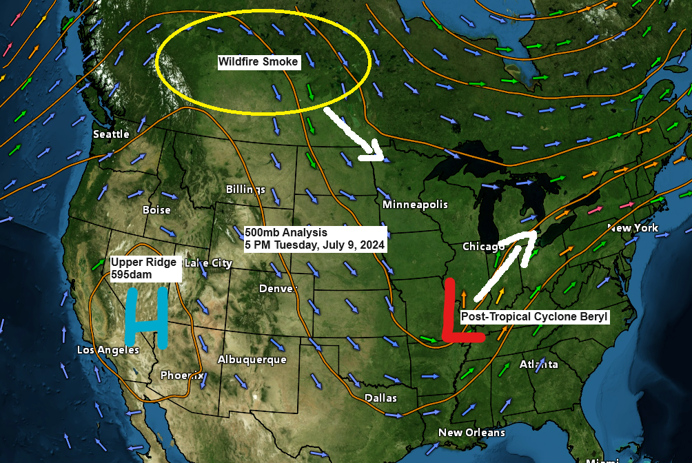
Intense heat persisted today across the western and southwest U.S., with widespread temperatures ranging from 95 to 105 degrees or higher, and the 90s reaching into northwest Canada this afternoon.

Today marked the fourth instance this month of temperatures reaching or exceeding 80 degrees in Duluth, and it’s likely that we’ll add several more days to that tally through next Monday. Highs in the 80s are expected Thursday, Friday, Saturday, Sunday, and Monday. However, it’s unlikely that we’ll see temperatures hit 90 degrees in Duluth over the weekend.

Post-Tropical Storm Beryl is delivering widespread rainfall across the Midwest and Ohio Valley today, accompanied by several severe thunderstorms that could spawn tornadoes, particularly in the red-outlined areas on the radar loop, on the southeast flank of the system.
Radar loop ends 4:56 PM CT, Tuesday, July 9, 2024.
Thanks for reading!
Tim
Leave a Reply