5:59 PM Wednesday, July 10, 2024
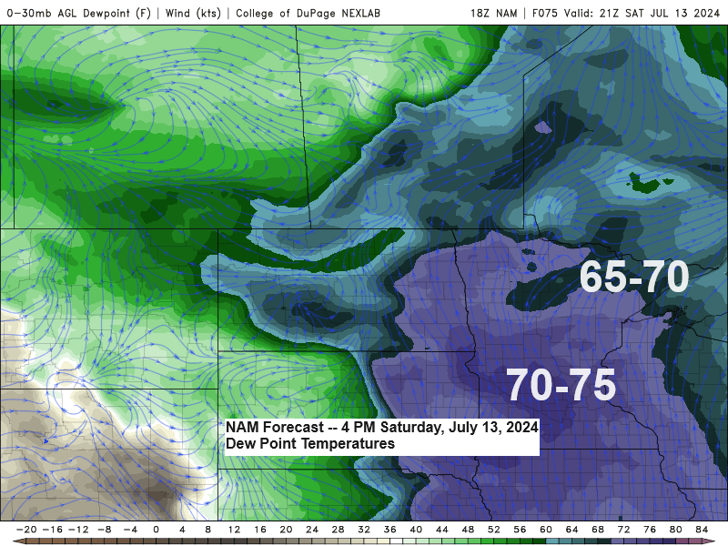
The Northland is set to experience a warm pattern with rising humidity levels over the coming days. The most oppressive conditions are anticipated this weekend, with dew points possibly reaching 70 or higher across the region.
It appears unlikely that Duluth will reach 90 degrees this weekend; however, widespread temperatures in the 80s are anticipated throughout the Northland, including the Twin Ports. Temperatures may be slightly cooler if cloud cover is more extensive over the weekend, along with potential showers and thunderstorms, particularly on Sunday.
This weekend, we are expecting a significant increase in instability, along with stronger winds aloft originating from the northern Plains and upper Midwest. This combination could result in some strong to severe thunderstorms, potentially affecting parts of the Northland on Saturday and Sunday, and possibly continuing into the following Monday.

Heads up! The map’s yellow shaded area indicates the potential for isolated to scattered severe thunderstorms on Sunday.

A clearly defined mid/upper-level low is tracking south-southeast across Minnesota and Iowa today, while post-tropical cyclone Beryl proceeds on its northeastward journey across the eastern Great Lakes.
Goes-16 water vapor loop from Wednesday, July 10, 2024, loop time ends 3:50 PM CT.

Today, scattered showers and thunderstorms have been advancing southward across regions of Minnesota and Wisconsin. These storms have brought heavy downpours this afternoon.
Radar loop ends 5:10 PM Wednesday, July 10, 2024.
The showers and thunderstorms in the Northland this afternoon occurred near a westward/southward-moving lake breeze front.
Radar rainfall estimates through 5 PM Wednesday.

Today, the upper Midwest was under a north-northwest flow aloft, positioned between an eastern trough and a significant upper ridge (heat wave) dominating the western U.S.

Post-tropical Cyclone Beryl is causing widespread rain and thunderstorms across the northeastern U.S. today, with numerous severe thunderstorms that have the potential to produce tornadoes.
Red polygons=Tornado Warning
Yellow polygons=Severe Thunderstorm Warning
Radar loop ends 5:14 PM CT Wednesday, July 10, 2024.
Today, intense heat persisted across the western United States, with temperatures soaring into the 90s and 100s. This heatwave extended far north, reaching into Alberta, Saskatchewan, and Manitoba in Canada.

Today, a stronger northeast wind off Lake Superior has resulted in cooler temperatures near the lake. However, as the lake’s temperature has increased recently, the lake breezes are not as cold as they were a few weeks ago.
This afternoon, temperatures are reaching the upper 60s to around 70 at the lakefront, while just a few weeks ago, a brisk northeast wind would have kept temperatures in the 50s.

Computer models are beginning to show cooler trends for next week’s forecast.
It’s worth noting that below-average temperatures in mid-July typically result in highs in the 70s and lows in the 50s in Duluth. So, it’s not exactly cold, but it is somewhat cooler than what’s usual for this period.
Below average temperatures in blue and green colors on the map below.

The GEFS model indicates a slight trend towards cooler temperatures (blue colors) for the period of July 14-19, 2024, in its latest forecast (days 5-9) compared to previous runs.

Thanks for reading!
Tim
Leave a Reply