5:43 PM Friday, July 12, 2024
The weather forecast indicates that northeast Minnesota and northwest Wisconsin will experience a couple rounds of showers and thunderstorms from Saturday morning through Monday. Be prepared for changing weather conditions and stay safe!
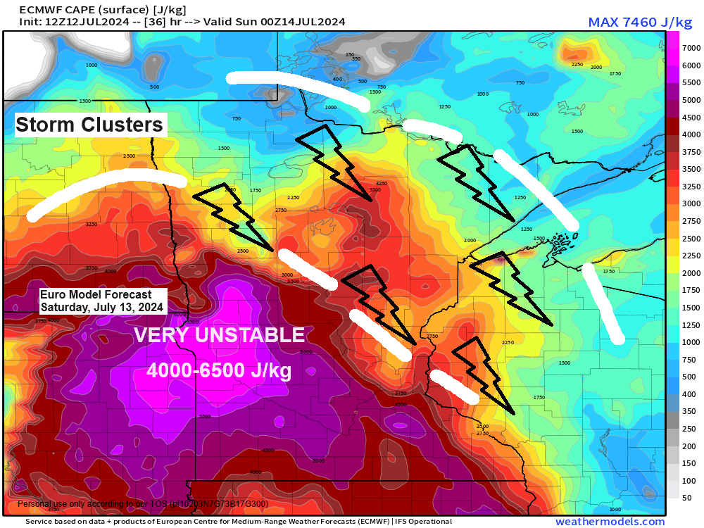
From Saturday through Monday, some storms may become strong to severe, bringing damaging winds and large hail as the main threats. Additionally, torrential downpours are expected in areas where storms occur.
This weekend, expect high temperatures in the 70s and 80s on both Saturday and Sunday, with humid conditions and dew points in the 60s and 70s. However, it might feel a bit less humid on Sunday, particularly in northern Minnesota.
The Northland is facing a slight risk (level 2 out of 5) for severe thunderstorms on Saturday and Saturday night. The main threats include damaging wind gusts of 60 mph or higher and large hail ranging from quarter size to ping pong ball size (1″ to 1.5″ in diameter). Stay safe and keep an eye on weather updates!


NAM 3km model simulated radar forecast valid from Midnight tonight to 7 AM Sunday.

HRRR model simulated radar forecast valid from Midnight tonight to 7 AM Sunday.

Maximum rainfall totals of 1 to 2 inches or more are possible from Saturday to early Sunday morning over parts of east-central Minnesota and northwest Wisconsin, with generally a half inch to an inch or more of rain expected in northern Minnesota, according to the HREF model forecast.

Here’s the HREF model matched mean rainfall forecast through 7 AM Sunday.

As is often the case with thunderstorm setups, there is considerable disagreement among computer models regarding where storms will occur on Saturday and their timing. This variability is due to the complex nature of weather systems and the different ways models interpret atmospheric data.
Here are two examples for Saturday afternoon at 4 PM.
One model shows an active late Saturday afternoon/evening with a few areas of strong to severe thunderstorms tracking south/east through parts of the Northland.

But then here’s another computer model forecast also for 4 PM Saturday which shows no thunderstorm activity anywhere in the Northland.

High temperature reports from Friday, July 12, 2024, and the record high temperatures for today’s date.
Ashland, WI: 88 (record high 105 set in 1936)
Duluth, MN: 86 (record high 102 set in 1936)
International Falls, MN: 86 (record high 96 set in 1921)
Brainerd, MN: 85 (record high 103 set in 1936)
Hibbing, MN: 84 (record high 91 set in 1966 and 1969)
It was a warm Friday across the Northland with widespread 80s this afternoon.

It was a bit humid in the Northland this afternoon, with dew points ranging from the mid-50s to lower 60s. However, a more humid air mass was present just west and south of our area, with dew points in the upper 60s to mid-70s. This air mass is expected to move into the Northland on Saturday, bringing dew points between 64 and 73 degrees.

Thanks for reading!
Tim
Leave a Reply