5:15 PM Monday, July 15, 2024
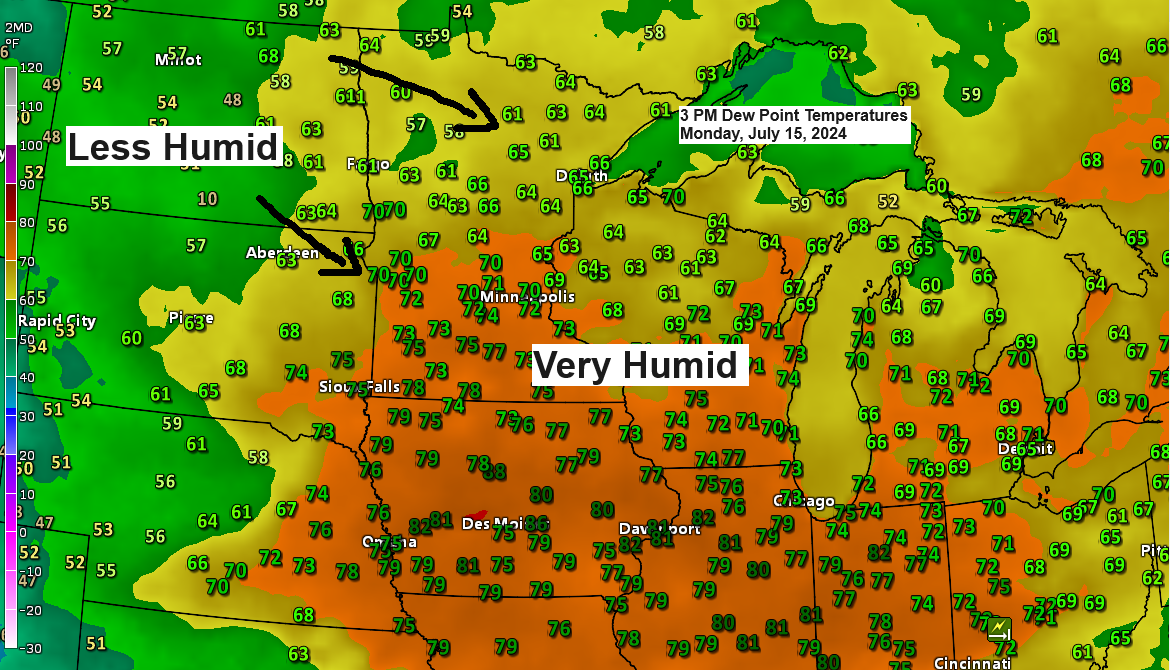
It’s been quite muggy lately, with dew points in the 60s and 70s across much of the Upper Midwest. However, relief is on the way! Starting Tuesday, dew points in the Northland will drop into the 40s and 50s, bringing much drier air. This refreshing change is expected to last at least through Friday.
Outside of a few passing showers on Tuesday, the rest of this week looks dry at the moment.
- Today, Monday, July 15th marked the 9th day this month with a high of at least 80 degrees in Duluth. The average number of 80-degree days in July is 11 days.
- Duluth has experienced a warm streak with temperatures reaching at least 80 degrees for five consecutive days (July 11th-15th). However, this streak is expected to end on Tuesday.
Note: International Falls has seen almost 1.75 inches more rain than usual so far this month, while Ashland and Duluth are experiencing significant deficits, with Ashland nearly 1.50 inches below normal and Duluth over 1.25 inches below normal.
Updated rainfall totals for July, through 4 PM on the 15th
International Falls, MN: 3.91 inches, +1.70 inches above normal
Brainerd, MN: 2.04 inches, -0.23 inches below normal
Hibbing, MN: 1.15 inches, -0.99 inches below normal
Duluth, MN: 0.82 inches, -1.30 inches below normal
Ashland, WI: 0.33 inches, -1.49 inches below normal
Scattered showers and thunderstorms will continue to move southeast across northwest Wisconsin and extreme northeast Minnesota into early this evening. While no severe weather is expected, brief heavy downpours and gusty winds up to 40 mph are possible.
Radar loop ends 4:22 PM CT Monday, July 15, 2024.
A significant severe weather event is expected tonight in parts of Iowa, southern Wisconsin, and northern/central Illinois. The primary threat will be widespread damaging winds of 60 to 85 mph, but large hail and a few tornadoes are also possible.

Severe thunderstorms have been developing this afternoon over northern and central Iowa. These storms are expected to form into an intense bow echo, leading to damaging winds as they move east-southeast through the evening.
Radar loop ends 4:28 PM Monday, July 15, 2024.
Here’s a look at the severe storms over Iowa on satellite imagery.
Goes-16 infrared satellite loop.
Loop time ends 4:36 PM CT Monday, July 15, 2024.

The atmosphere ahead of the storms in Iowa is highly unstable this afternoon, with Convective Available Potential Energy (CAPE) exceeding 4000 J/kg. This level of CAPE indicates extreme instability, which can lead to severe thunderstorms if other conditions are favorable.

It looks like parts of the Northland might experience a few showers on Tuesday, thanks to a trough moving in from Ontario.
HRRR model simulated radar forecast valid 10 AM Tuesday to 10 PM Tuesday.

Goes-16 water vapor loop from Monday, July 15, 2024, loop time ends 3:30 PM CT.

With the 500mb heights lowering due to the mid and upper-level trough moving south/east from Ontario, you can expect some pleasant summer days ahead. Enjoy the comfortable weather!

Cooler temperatures in the lower to middle 70s will be moving into the Northland the next few days but we could see 80s return again late in the week and this weekend. Overnight temperatures for Tuesday night and Wednesday night are forecast to dip into the 40s and 50s.
The central, southern, and eastern U.S. are experiencing widespread heat today. While the southwest and western U.S. have seen a slight cooldown compared to the intense heat of recent days, temperatures remain high.

Thanks for reading!
Tim
Leave a Reply