6:12 PM Thursday, July 25, 2024
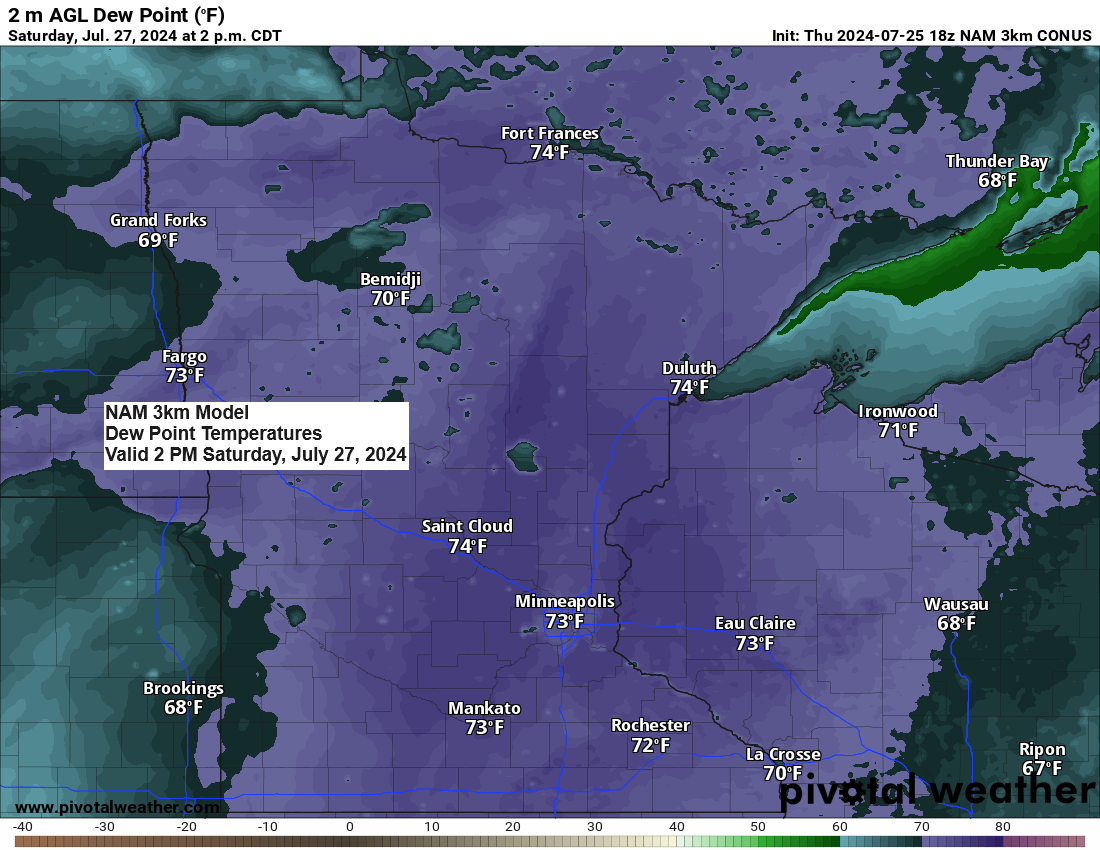
Over the next few days, the Northland will experience some discomfort as temperatures rise and humidity levels reach tropical classifications. Dew points will climb into the 60s and may reach 70 degrees by Friday afternoon, and they are expected to range from 65 to 75 degrees over the weekend. This surge in humidity, coupled with temperatures in the 80s on Friday and escalating to the lower 90s in parts of the Northland by Saturday and Sunday, will create a rather stifling atmosphere. Although there will be a presence of southerly winds blowing at 15 to 25 mph, it’s uncertain how much relief they will provide from the muggy conditions.
Hibbing, Minnesota nearly matched its record low temperature for July 25th, registering a low of 43 degrees this morning. The standing record low for this date is 42 degrees, which was set in both 2001 and 2004.
This weekend, scattered showers and thunderstorms are forecasted primarily for the north central regions of Minnesota. Meanwhile, eastern Minnesota, the Twin Ports area, and northwest Wisconsin are expected to experience predominantly dry conditions until Sunday night or Monday. The showers and thunderstorms are associated with a cold front anticipated to move eastward out of the Dakotas at a slow pace this weekend. Note: The likelihood of severe thunderstorms remains low in our area for the weekend; however, there is a possibility of heavy rain and a few strong storms on both Saturday and Sunday, primarily affecting northern Minnesota.
Take a look at the NWS Blend of Models rainfall forecast for this weekend, concluding at 7 PM on Sunday.
Note: It seems that Duluth will stay predominantly dry over the weekend, with the likelihood of rain at times persisting to the west and north.

Make a one-time donation
Make a monthly donation
Make a yearly donation
Choose an amount
Or enter a custom amount
Your contribution is appreciated.
Your contribution is appreciated.
Your contribution is appreciated.
DonateDonate monthlyDonate yearlyThe intense heat persisted today, shifting slightly eastward from the previous days.
The western Dakotas and eastern Montana experienced the bulk of the heat. Here are some temperatures recorded at 5 PM on Thursday.
- Watford City, ND: 109
- Buffalo, SD: 108
- Rapid City, SD: 107
- Philip, SD: 107
- Baker, MT: 106
- Dickinson, ND: 105
- Faith, SD: 104
- Miles City, MT: 102

Today, a very humid air mass extended from central Canada through the central and eastern Dakotas to eastern Nebraska and Iowa, with dew points in the mid-60s to the low and mid-70s. Meanwhile, a significantly less humid air mass covered northeast Minnesota and northwest Wisconsin. However, this is expected to change in the coming days, with dew point temperatures rising into the 60s and 70s across the Northland.

The upper-level ridge linked to the intense heat is moving further north and east today, with its core extending from central Canada through the northern Plains to the southwest U.S., reaching 500mb heights of approximately 596 to 598 decameters.

Heading into next week, an upper-level ridge over the southern Plains is expected to move northwestward, accompanied by increasing 500mb heights over the Pacific Northwest. Concurrently, the westerly flow aloft will revert to a northwest flow across the upper Midwest. Despite these changes in the upper-level wind patterns, the forecast still indicates a relatively warm week ahead in the Northland.

Thanks for reading!
Tim
Leave a Reply