5:20 PM Monday, July 29, 2024
Today, Monday, July 29th, is the fifteenth day of the month that Duluth has seen temperatures reach at least 80 degrees. If the temperature hits 80 degrees on both Tuesday and Wednesday, it will increase the count of 80-degree days to seventeen for this month. The average for July is eleven days with temperatures of 80 or above.
Record high minimum temperatures were recorded in the Northland on July 27th, 2024. Details are provided below.
Duluth: 72 degrees. Previous record 68 degrees set in 1949 and 1941
Hibbing: 71 degrees. Previous record 69 degrees set in 1941.
International Falls: 69 degrees. Previous record 68 degrees set in 1983.
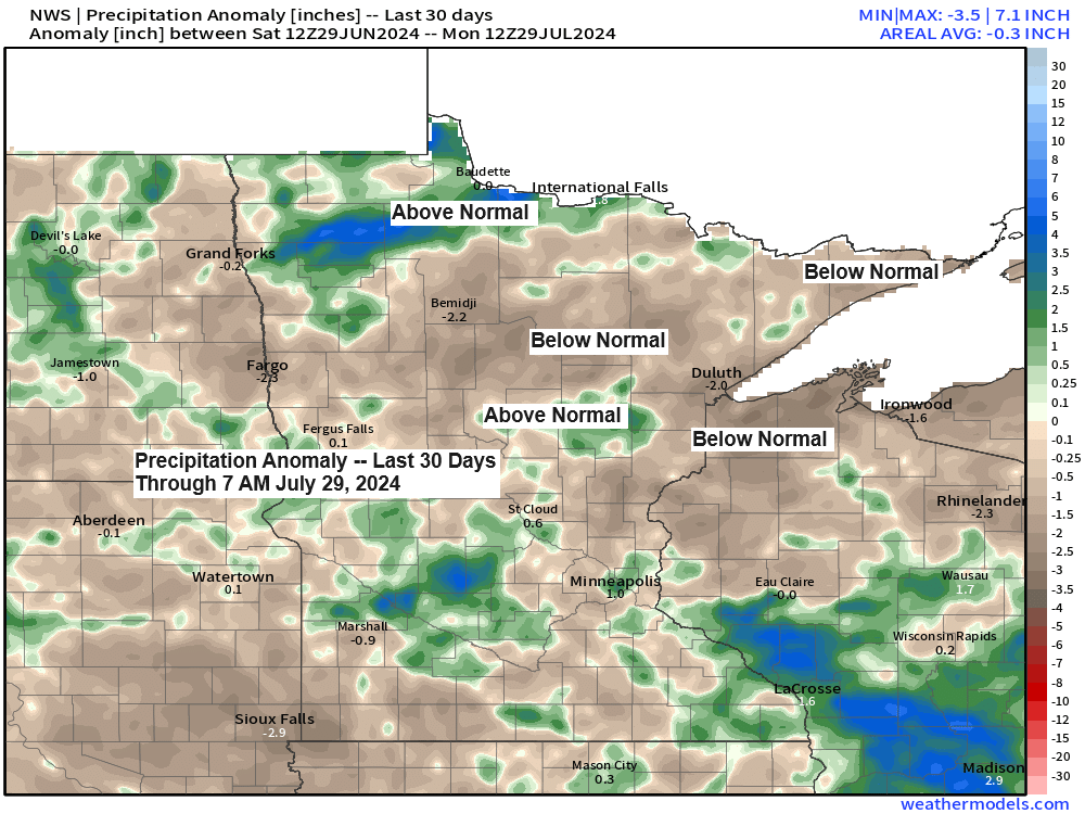
The Northland region is currently experiencing rainfall levels that are 1 to 2 inches below the monthly average, whereas International Falls has exceeded its average rainfall by more than an inch.
Rainfall anomalies for July 2024 as of 4 PM on the 29th
- Duluth, MN: -2.45 inches below normal
- Hibbing, MN: -2.44 inches below normal
- Brainerd, MN: -1.69 inches below normal
- Ashland, WI: -1.54 inches below normal
- International Falls, MN: +1.09 inches above normal
Widespread rainfall is not expected in the Northland area this week, however, there will be chances for scattered showers on Tuesday and possibly between Wednesday and early Thursday. Heavier downpours may occur where these showers are present.

Make a one-time donation
Make a monthly donation
Make a yearly donation
Choose an amount
Or enter a custom amount
Your contribution is appreciated.
Your contribution is appreciated.
Your contribution is appreciated.
A severe thunderstorm watch is currently in place until midnight tonight for regions of North and South Dakota, as well as the far northern area of Nebraska, indicated by the yellow area on the map. This evening, the primary severe weather threats are scattered damaging winds ranging from 60 to 75 mph and large hail measuring 1 to 2 inches in diameter.

Scattered, strong to severe thunderstorms are expected to move east across parts of the Dakotas tonight. Some of these storms may persist into parts of the Northland by Tuesday morning; however, they should significantly weaken by the time they arrive in our area.
There is also a possibility of additional showers and thunderstorms developing on Tuesday afternoon, primarily across regions of northwest Wisconsin.
NAM 3km model simulated radar forecast valid from Midnight tonight to 10 PM Tuesday.

Another warm afternoon graces the Northland, with temperatures widely in the 80s.

Drier air has made its way into parts of northern Minnesota today, with dew points dropping to the upper 50s and lower 60s. However, in other areas, the humidity persists with dew points ranging from the 60s to about 70 degrees.
It appears that there won’t be significant relief from the high dew points (humid air mass) until early next week.

Today, an active weather pattern continues across the northern U.S., with various systems affecting different regions. Simultaneously, an upper-level ridge is redeveloping over the southern Plains. This ridge is expected to strengthen and extend further northwest in the coming days.

Goes-16 water vapor loop ending 4:40 PM CT, Monday, July 29, 2024.

Thanks for reading!
Tim
Leave a Reply