6:49 PM Wednesday, July 31, 2024
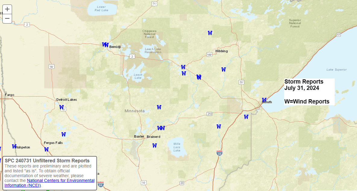
Storm Reports for July 31, 2024
Source: National Weather Service Duluth, Minnesota
- 6:45 PM: Marine Thunderstorm Wind. 47 mph. 4 WNW Two Harbors, MN (Lake County)
- 6:08 PM: Thunderstorm Wind Damage. 1 W Side Lake, MN (St. Louis County) 1-inch tree limbs broken, and shingles blown off.
- 5:35 PM: Marine Thunderstorm Wind Gust. 53 mph. Duluth Sky Harbor Airport (St. Louis County)
- 5:33 PM: Thunderstorm Wind Damage. Wrenshall, MN (Carlton County) A tree was down near the Wrenshall city hall.
- 5:30 PM: Thunderstorm Wind Damage. 2 SW Lester Park, MN (St. Louis County) A roof was blown off of an addition to a home near Northwoods Country Club.
- 5:24 PM: Thunderstorm Wind Damage. 3 NE Toivola, MN (St. Louis County) 1-inch tree limbs broken, and shingles blown off.
- 5:09 PM: Thunderstorm Wind Damage. 1 SE Warba, MN (Itasca County) 1-inch tree limbs broken, and shingles blown off.
- 5:08 PM: Thunderstorm Wind Damage. 2 SE Warba, MN (Itasca County) 3-inch tree limbs broken.
- 4:55 PM: Hail 0.50 inch. 1 W Coleraine, MN (Itasca County)
- 4:48 PM: Thunderstorm Wind Damage. 5 S Grand Rapids, MN (Itasca County) A small pine tree was downed onto a power line and started a small fire.
- 4:45 PM: Thunderstorm Wind Damage. 1 NNW Grand Rapids, MN (Itasca County) Multiple mature pine trees down along US2 in Grand Rapids.
- 4:39 PM: Thunderstorm Wind Damage. 1 N Kettle River, MN (Carlton County) Reports of branches down with a mature pine tree down across the road on the north side of town.
- 4:13 PM: Thunderstorm Wind Damage. McGregor, MN (Aitkin County) Two dock pieces blowing across a parking lot.
- 3:48 PM: Thunderstorm Wind Damage. 1 S Emily, MN (Crow Wing County) Tree down on power lines near Pine ridge cemetery in Emily.
- 3:44 PM: Thunderstorm Wind Damage. Deerwood, MN (Crow Wing County) A tree was downed onto a garage.
- 3:40 PM: Thunderstorm Wind Damage. 1 SW Crosby, MN (Crow Wing County) 3-inch tree limbs broken.
- 3:21 PM: Thunderstorm Wind Damage. 7 WNW Pine Center, MN (Crow Wing County) Tree down on power lines at the intersection of County Roads 23 and 104.
Afternoon thunderstorms, accompanied by strong winds, have led to multiple power outages in the Northland area.


Note: The likelihood of severe thunderstorms remains high for the remainder of tonight, particularly across central and southern Minnesota.
While scattered showers and some thunderstorms are expected to persist in parts of the Northland tonight, the likelihood of severe thunderstorms has significantly decreased for the remainder of the evening.
Radar loop ends 6:28 PM CT Wednesday, July 31, 2024.
Make a one-time donation
Make a monthly donation
Make a yearly donation
Choose an amount
Or enter a custom amount
Your contribution is appreciated.
Your contribution is appreciated.
Your contribution is appreciated.
DonateDonate monthlyDonate yearlyRainfall Reports for July 31, 2024, as of 6:38 PM Wednesday
Source: MesoWest
Hill City, MN: 0.85″
Grand Rapids, MN: 0.46″
Orr, MN: 0.38″
Hibbing, MN: 0.28″
Nashwauk, MN: 0.23″
Cass Lake, MN: 0.19″
Brainerd, MN: 0.17″
McGregor, MN: 0.14″
Moose Lake, MN: 0.14″
Keewatin, MN: 0.05″
Thanks for reading!
Tim
Leave a Reply