6:17 PM Monday, December 2, 2024
My blog has surpassed 50 total subscribers, and I want to express my gratitude to those who have subscribed. Recently, I chose to place some content, such as my snowfall forecasts and analyses of systems affecting our region, behind a paywall. Having never done this with my weather content before, I was uncertain about the outcome. However, I must admit that the support I’ve received since implementing this change in late August has been pleasantly surprising.

Just a reminder, the Black Friday promotion extends until this Friday. The annual subscription is offered at $35, reduced from the regular price of $60. You can find the subscription link further down in this post. Thank you!
A winter storm watch will be in effect for the Arrowhead region, encompassing parts of the North Shore of Lake Superior, from Tuesday afternoon through Tuesday evening. This includes the cities of Tofte, Lutsen, Grand Marais, and Grand Portage.
Further down in this post, I will provide additional details on Tuesday’s system, including my forecast for snowfall during this event.

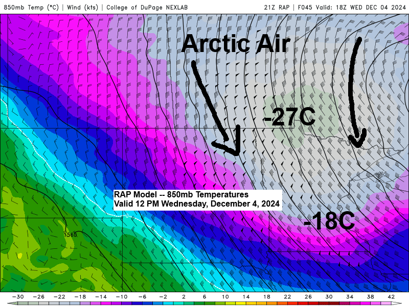
On Tuesday, a surge of warm air advection (indicated by red on the loop) will occur, which will then be succeeded by a significant influx of cold air advection (shown as blue on the loop) on Wednesday.
The shifting airmasses are expected to bring windy conditions, with southerly winds on Tuesday transitioning to the northwest by Wednesday. Wind gusts could range from 15 to 35 mph on both days.
RAP model forecast valid 12 PM Tuesday to 12 PM Wednesday.

The Northland will experience a brief period of milder air Tuesday night with temperatures climbing into the 20s and lower 30s. However, this will be swiftly followed by a return of cold air, causing temperatures to plummet into the single digits by late Wednesday afternoon.
European model temperature forecast valid 12 PM Tuesday to 6 PM Wednesday.

It may take some time, but there are indications from computer models that a weather pattern change could occur sometime next week.
This week’s weather pattern will persist with a deep trough over the eastern United States and a robust ridge to the west. Consequently, the Northland will remain under a northwest flow aloft, minimizing the likelihood of any significant systems impacting our region.

Heading into next week, the weather pattern could shift, marked by a decrease in the 500mb heights and the development of troughing across western/central Canada and the western U.S., while a ridge forms over the southern/eastern U.S. This pattern could lead to a greater likelihood of more organized systems affecting the upper Midwest and the western Great Lakes region.

Next week, there is a potential issue with temperatures rising enough to affect the type of precipitation if a system moves through the Northland area, meaning the precipitation may not be solely snow.


Subscribe to continue reading
Become a paid subscriber to get access to the rest of this post and other exclusive content.