10:34 AM Sunday, December 8, 2024
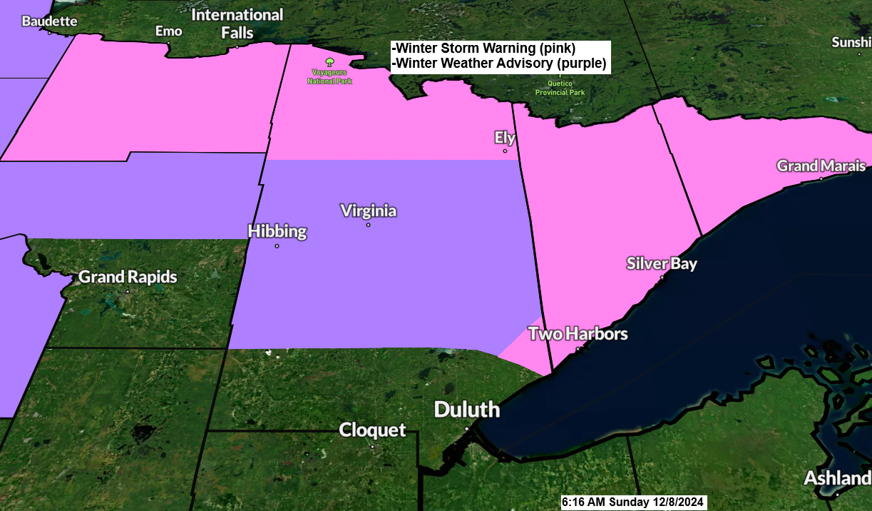
-Winter Storm Warnings have been expanded to cover far northern Minnesota and the entire North Shore of Lake Superior, encompassing cities such as International Falls, Ely, Orr, Crane Lake, Two Harbors, Silver Bay, Isabella, Tofte, Lutsen, and Grand Marais.
-A Winter Weather Advisory is in effect for various parts of Northeast Minnesota, encompassing cities such as Hibbing, Virginia, Bigfork, Cass Lake, and Walker.
-These winter weather headlines are in effect through Monday morning.
-The heaviest rates of precipitation are expected this afternoon and evening.
-East winds are expected to increase, with gusts ranging from 15 to 30 mph near Lake Superior this afternoon and into the evening, resulting in patchy blowing snow along the North Shore.

The primary challenge in the forecast is determining the southern extent of the accumulating snow, which is influenced by a marginally cold air mass enveloping the area this morning.
As of 9 AM, temperatures were in the low to mid-30s, with the exception of the Arrowhead region of Minnesota, which was in the 20s. It’s likely that these temperatures will remain fairly stable throughout the day and into the evening, with a possible fluctuation of plus or minus 1 to 3 degrees.

Temperatures at the 850mb level range from -3 to -5°C across the Arrowhead region of Minnesota this morning. Given the presence of a deeper layer of cold air in this area, snow is anticipated to be the predominant form of precipitation during this event.
Further west and south, however, there is more uncertainty due to slightly warmer temperatures at the 850mb level, ranging from about +2 to -3°C (warmest farther south). For snow to occur, the 850mb temperature must be below 0°C, provided that surface temperatures are sufficiently cold, typically below 34 degrees.
With the persistence of a warm advection pattern into this evening, there are concerns about whether precipitation will fall as snow or rain, or transition from snow to rain during the afternoon and into the evening.


An additional complexity in predicting precipitation types for this event is the presence of Lake Superior and its above-normal water temperatures that persist.
East winds, influenced by the lake’s average water temperature of 43 degrees, may result in warmer conditions today, potentially leading to more rain than snow in lower elevations, including the Duluth area. However, there is low confidence in the precise weather outcomes for this afternoon.

The surface map from mid-morning shows two low-pressure areas: one over southern Saskatchewan, Canada, and the other over east-central South Dakota.

The radar indicates precipitation moving eastward across the Northland this morning, with various types of precipitation detected. These range from snow (indicated by blue) to rain (green), and occasionally a mix of both (pink).
Note: Snow or a mix should reach the Duluth area around Noon today.
Radar loop ends 10:12 AM Sunday, December 8, 2024

Subscribe to continue reading
Become a paid subscriber to get access to the rest of this post and other exclusive content.