6:52 PM Wednesday, December 18, 2024
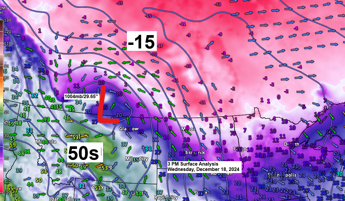
Low pressure was centered between Cypress Hills Park and Swift Current in southern Saskatchewan, Canada, this afternoon, and wow, what a huge temperature contrast we have with this system, with temperatures in the single digits and teens below zero north of the low to the 50s south of the low over central parts of Montana this afternoon.
The 850mb temperature gradient is equally remarkable this late afternoon, ranging from +10 in central Montana to -18°C in far northeast Minnesota.

Storm Track — Lake Effect Snow Potential
Low pressure will move into western areas of North Dakota tonight and is forecast to reach northeast South Dakota around daybreak on Thursday. This low will then continue on a southeast track, reaching eastern portions of Iowa late Thursday afternoon or early evening.
With the low passing south of the Northland, this will cause winds to shift to an easterly direction on Thursday, and with east winds crossing Lake Superior and plenty of cold air available (850mb temperatures of -11 to -14°C), this will likely cause some enhancement in the snow along the North Shore of Lake Superior and in the Duluth area Thursday into early Thursday evening. Winds will then shift to the north-northwest Thursday evening/overnight, which will shift the lake effect snow potential to the South Shore of Lake Superior in northwest Wisconsin.

Snowfall Timing
-Snow is forecast to spread east-southeast across much of the Northland Thursday morning, beginning in western areas after midnight tonight and reaching northwest Wisconsin around daybreak Thursday.
Duluth area: Snow is expected to begin early Thursday morning between 4 AM and 6 AM. It will diminish between 10 PM Thursday and 1 AM Friday. East winds gusting 15 to 25 mph could cause areas of blowing snow during the day on Thursday. Winds will shift to the north-northwest Thursday evening with gusts up to 25 mph.
Should also be noted that with plenty of cold air in place, the snow that falls and accumulates will be light and fluffy and not the heavy/wet type of snow.

Winter Weather Headlines
- Winter Storm Warnings and Winter Weather Advisories are in effect from late tonight through late Thursday night for much of northeast Minnesota and all of northwest Wisconsin.


Subscribers gain access to my snowfall forecasts. The price to subscribe has been reduced from $60 to $35 for an annual subscription through December 25th, or a monthly subscription price of $5. Thank you.

Subscribe to continue reading
Become a paid subscriber to get access to the rest of this post and other exclusive content.