11:32 AM Sunday, February 2, 2025
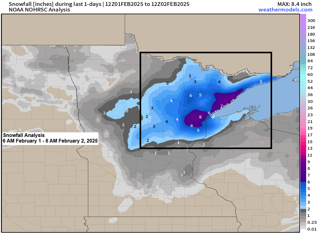
A snowy system moved through the Northland from Saturday to early Sunday, delivering several inches of snow to parts of northeast Minnesota and extreme northwest Wisconsin.
Snowfall in the Duluth metro area was mostly 4 to 6 inches, with one report of 7 inches near Lester Park.
-Duluth, Minnesota set a new 24-hour snowfall record on February 1st, receiving 4.2 inches of snow, surpassing the old record of 4.0 inches from 2004.
-International Falls, Minnesota set a new 24-hour snowfall record on February 1st with 3.9 inches of snow, breaking the old record of 3.1 inches from 2009.
February 1-2, 2025, Snowfall Reports
- 2 ENE Lutsen, MN: 8.0″
- 1 NW Chisholm, MN: 8.0″
- 1 W Silver Bay, MN: 7.9″
- Two Harbors, MN: 7.1″
- 3 SW Lester Park, MN: 7.0″
- Silver Bay, MN: 7.0″
- 4 W Grand Marais, MN: 6.9″
- 3 NNW Mahtowa, MN: 6.9″
- 7 NNE Wales, MN: 6.8″
- 2 WSW Lester Park, MN: 6.6″
- Castle Danger, MN: 6.5″
- 2 NW Two Harbors, MN: 6.5″
- 2 SW Gary New Duluth, MN: 6.4″
- 2 SE Tamarack, MN: 6.4″
- 3 WSW Cloquet, MN: 6.3″
- 1 WNW Proctor, MN: 6.1″
- 6 NNW Ely, MN: 6.1″
- 2 WSW Superior, WI: 6.1″
- 1 W Cromwell, MN: 6.1″
- Duluth, MN: 6.1″ (Official total at the NWS)
- 2 NNE Fond Du Lac, MN: 6.0″
- 2 NNE Duluth, MN: 6.0″
- 1 ENE Superior, WI: 6.0″
- 3 ESE Libby, MN: 5.9″
- Esko, MN: 5.8″
- 1 ENE Hoyt Lakes, MN: 5.7″
- 1 NW Island Lake, MN: 5.6″
- Lester Park, MN: 5.5″
- 3 SE Ely, MN: 5.4″
- 2 S Brimson, MN: 5.4″
- 1 SSE International Falls, MN: 5.3″
- 1 NW Hermantown, MN: 5.3″
- 10 ESE Sawbill Lake, MN: 5.1″
- 6 NE Castle Danger, MN: 5.0″
- 2 NNW Kerrick, MN: 5.0″
- Embarrass, MN: 5.0″
- 7 SSW Hoyt Lakes, MN: 5.0″
- 4 ESE Moose Lake, MN: 4.9″
- 1 SSW Superior, WI: 4.5″
- 3 NW Hovland, MN: 4.5″
- Cook, MN: 4.5″
- 3 ENE Holyoke, MN: 4.4″
- 3 SSE Coleraine, MN: 4.4″
- 3 E Orr, MN: 4.3″
- 8 NNW Bovey, MN: 4.0″
- 1 WSW Maple, WI: 4.0″
- 1 NW International Falls, MN: 4.0″
- 3 N Amnicon Falls, WI: 4.0″
- 1 N Bayfield, WI: 3.7″
- 1 SW Crosby, MN: 3.6″
- Solon Springs, WI: 3.4″
- Brainerd, MN: 3.3″
- 4 SE McGrath, MN: 3.0″
- Gile, WI: 3.0″
- 8 ESE Northome, MN: 3.0″
- 6 NW Finlayson, MN: 3.0″
- 3 ENE Wright, MN: 3.0″
- 1 E Baxter, MN: 2.8″
- 8 ESE Brainerd, MN: 2.6″
- 5 S Herbster, WI: 2.5″
- 1 SE Cornucopia, WI: 2.3″
- Seeley, WI: 2.0″
- 9 ESE Seagull Lake, MN: 2.0″
- 1 SW Hayward, WI: 2.0″
- 1 SSW Pine City, MN: 1.8″
- Washburn, WI: 1.7″
- 1 N Washburn, WI: 1.6″
- 1 SW Grantsburg, WI: 1.5″
- Butternut, WI: 1.5″
- 4 SE Webb Lake, WI: 1.0″
- 7 ENE Sarona, WI: 0.6″
Subscribers gain early access to these snowfall forecasts.
Here’s the evolution of my snowfall forecasts for this event.
Overall, my forecasts have been better. For whatever reason the computer models had difficulty with this system, and as a forecaster, my accuracy relies on the data. If the data is incorrect, the forecast is likely to be incorrect as well.
Note: The forecast I made on Friday was likely closest to reality for this event.
My initial forecast was issued on Wednesday, January 29th, 2025.

Updated forecast made on Thursday, January 30th, 2025.

And one more update on Friday, January 31st, 2025.

Thanks for reading!
Leave a Reply