5:17 PM Saturday, February 1, 2025

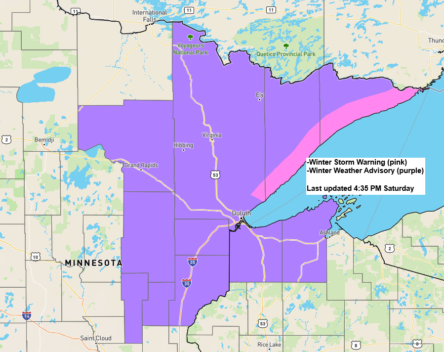
– Winter Storm Warnings and Advisories remain in effect in parts of the Northland through early Sunday morning.
-Snow will continue tonight, although it will start to taper off from west to east early Sunday morning.
-Heaviest snow is expected until around midnight tonight in northeast Minnesota, including the Twin Ports area. Note: Some places may see snowfall rates of 0.5 to 1 inch per hour this evening.
-East winds blowing at 15 to 30 mph will create blowing snow tonight, particularly along the North Shore of Lake Superior.
-Patchy freezing drizzle may develop in parts of the Northland late tonight/early Sunday morning after the snow stops.
Here’s my updated snowfall forecast (final one for this event)
- 4 to 8 inches of snow along the North Shore
- Anywhere from 1 to 4 inches of snow across the rest of the Northland
- Duluth area: 2 to 4 inches of snow by 6 AM Sunday.
As of 4 PM Saturday, 0.8 inches of snow has fallen in Duluth.
Note, according to the EPS model (Euro Ensemble), Duluth has an >80% chance of getting at least 4 inches of snow tonight, with a 20% chance of getting more than 4 inches of snow.

Heaviest snowfall shows up in the green colors on the loop.
Radar loop ends 4:30 PM CT Saturday, February 1, 2025.
NAM 3km model simulated radar forecast through 6 AM Sunday.

A strong low-level jet out of the south has been blowing at 40 to 50 knots across the Northland today; this LLJ is fueling a lot of warm air advection-driven snowfall in our area, and with enhanced lift in the atmosphere (yellow/orange shaded area on the map), some of the snow has been on the heavy side this afternoon.
By late tonight, the low-level jet and forcing will decrease, causing the snow to ease up.

We have been seeing some convective elements (heavy bursts of snow) in the snow this afternoon over parts of east-central Minnesota, as noted by the lumpier appearance in the clouds.
Visible satellite loop ending 4:03 PM CT Saturday, February 1, 2025.
And a look at the wave impacting the Northland today via water vapor imagery.
Goes-16 water vapor loop ending 4:40 PM CT Saturday, February 1, 2025.

Today’s setup
A strong high pressure system with cold, dry air is located northeast of the Great Lakes, while a low pressure system bringing warmer, moist air is approaching from the west and south.


Subscribe to continue reading
Become a paid subscriber to get access to the rest of this post and other exclusive content.