5:12 PM Sunday, February 2, 2025
Updated snowfall data for Duluth, Minnesota after the recent snow.
*Seasonal Total: 30.7 inches (-22.7 inches below normal) We’ve had about 13 inches more snow this winter compared to last winter as of February 2nd.
*6.2 inches of snow have fallen this month in Duluth, almost matching the total of 6.6 inches from all of December in just the first 2 days.
*January 24th was the last time Duluth had a temperature below zero, reaching -12 degrees. Over the next two weeks, several nights with below-zero temperatures are expected in Duluth.
Another quick hitting snow event is expected late tonight into Monday morning, but this system should track farther south than the one on Saturday. As a result, only far southern parts of the Northland will see significant snow, while very little is expected farther north, including in the Duluth metro area.
There are still some differences in the computer models about where the narrow band of accumulating snow will form tonight and Monday morning, and any change in the system’s track will also change the location of the snow band.
These mesoscale bands of snow, which are forecast to occur tonight, are notoriously difficult to predict since they are often quite narrow. Also, these mesoscale bands of snow tend to overperform in terms of snow accumulation wherever they set up.
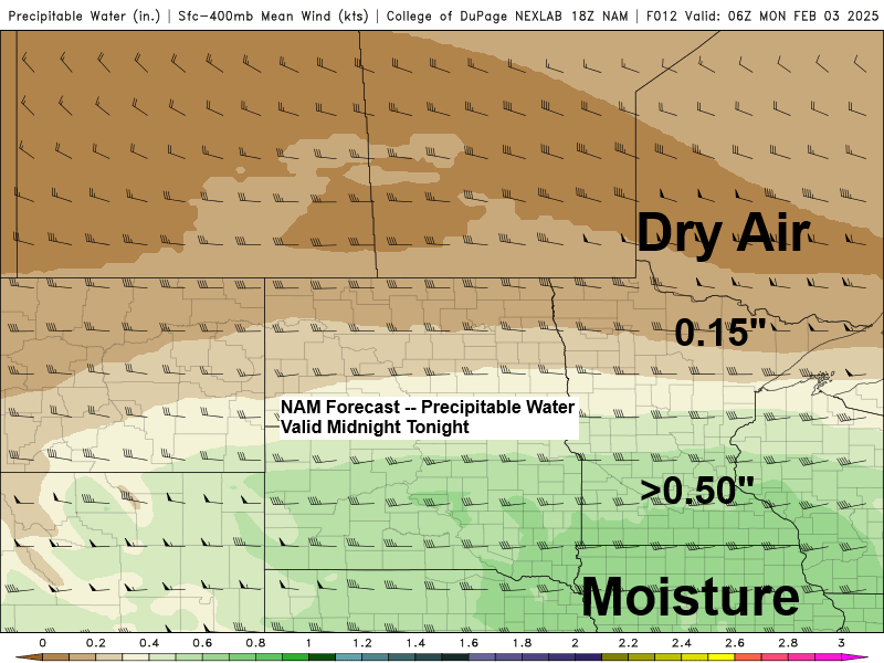
The amount of dry air forecast to set up across northern Minnesota should help to force tonight’s system more to the south. Surface winds will also be out of the north to northwest, which typically is not a very good direction to get much snow in the Twin Ports area.
- A Winter Weather Advisory is in effect for far southern portions of the Northland from late this evening to mid-morning on Monday for Hinckley, Pine City, Grantsburg, Danbury, Siren, Minong, Spooner, Shell Lake, Hayward, and Winter.


Here’s my snowfall forecast for this next event late tonight into Monday morning.
Again, there are some north/south differences in the computer models, most notably with the Euro model, as it continues to bring the snow farther north, which would lead to up to an inch of accumulation as far north as Duluth early Monday morning.

Saturday’s system continues to move off to the east this afternoon, while the next system is already spreading east into parts of the Dakotas.
Radar loop ends 4:22 PM Sunday, February 2, 2025.
An F-GEN snow band is expected to form late tonight most likely in central Minnesota and central Wisconsin, as winds at 850mb change from southwest to south-southeast, with northerly winds occurring slightly farther north.

NAM 3km model simulated radar forecast valid 7 PM this evening to Noon Monday.

Tonight’s system will also have a good temperature gradient to work with, ranging from about -5°F in northwest Minnesota to 32°F in southeast Minnesota.


Subscribe to continue reading
Become a paid subscriber to get access to the rest of this post and other exclusive content.