12:10 PM Saturday, February 15, 2025
My snowfall forecast was completely wrong for this event. I’m not going to sugarcoat things at all. It was a bust.
Snowfall totals ended up several inches above what was in the forecast for Friday to early Saturday morning. One reason behind this was the very large snowflake size. Large snowflakes (fluffy/dry snow) accumulate rapidly. We had a very favorable DGZ (dendritic growth zone) in place, which led to these large snowflakes. Forecast models showed a favorable DGZ for this event but indicated the main area of snow lasting only a short amount of time, leading to a general 1 to 2, maybe up to 3 inches of accumulation.
The signs were there Friday evening that this event would be an overachiever, but model guidance didn’t agree, and a forecaster is only as good as what the models show; if the models are off, the forecast will be wrong; in this case, snow totals ended up higher in much of the area.
-Reports of as much as 6 to 7 inches of snow last night in northern Douglas County Wisconsin around Wentworth and Hawthore.
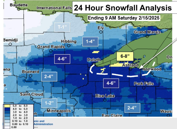
-Snowfall in the Duluth area was mostly between 4 to 6 inches, with similar amounts in Superior.
– Snow to liquid ratios greater than 30:1 were reported across parts of the Northland with this event. Typically, we see ratios around 14:1 in our area.
– A snowfall ratio of 60:1 was reported at the National Weather Service in Duluth, which is absolutely incredible. I don’t know if I’ve ever seen that around here before.
February 14-15, 2025, Snowfall Reports thru 11 AM on the 15th
- 3 SSW Wentworth, WI: 7.3″
- 3 WNW Hawthorne, WI: 6.5″
- 2 SW Gary New Duluth, MN: 6.0″
- 3 NE Herbster, WI: 6.0″
- 1 WSW Maple, WI: 6.0″
- 3 WSW Superior, WI: 6.0″
- 2 ESE Duluth, MN: 6.0″
- Washburn, WI: 5.9″
- 4 WNW Kerrick, MN: 5.8″
- Brule, WI: 5.6″
- Lester Park, MN: 5.5″
- 2 WNW Duluth, MN: 5.5″
- 2 WSW Superior, WI: 5.5″
- 1 WSW Lester Park, MN: 5.4″
- 3 ENE Holyoke, MN: 5.4″
- Ashland, WI: 5.4″
- 9.7 SSE Wrenshall, MN: 5.4″
- 6 W Washburn, WI: 5.3″
- Duquette, MN: 5.3″
- 6 SW Webb Lake, WI: 5.2″
- 2 NNE Fond Du Lac, MN: 5.1″
- 3 N Shaw, MN: 5.0″
- 4 SSW Shell Lake, WI: 5.0″
- Sandstone, MN: 5.0″
- 1 NW Island Lake, MN: 5.0″
- 3 ENE Wright, MN: 5.0″
- 5 SSE Libby, MN: 4.9″
- Moose Lake, MN: 4.9″
- 3 SW Lester Park, MN: 4.9″
- 7 N McGregor, MN: 4.9″
- 1 SW Hayward, WI: 4.8″
- 2 NE Cloquet, MN: 4.5″
- 7 ENE Sarona, WI: 4.4″
- 2 ESE Floodwood, MN: 4.4″
- 5 N Two Harbors, MN: 4.2″
- Coleraine, MN: 4.1″
- 4 SE Webb Lake, WI: 4.0″
- Cloquet, MN: 4.0″
- 4 NNE Grand Marais, MN: 4.0″
- 6 NW Finlayson, MN: 4.0″
- 7 SSW Grand Rapids, MN: 4.0″
- 1 SW Grantsburg, WI: 3.9″
- 2 NW Two Harbors, MN: 3.8″
- 4 SSE Webster, WI: 3.5″
- 7 NNE Wales, MN: 3.2″
- 1 W Silver Bay, MN: 3.1″
- 2 ENE Two Harbors, MN: 3.0″
- 2 SW Castle Danger, MN: 3.0″
- 1 NW Hurley, WI: 3.0″
- 5 NE Brainerd, MN: 3.0″
- 1 SSW Pine City, MN: 3.0″
- 1 ENE Hibbing, MN: 3.0″
- Two Harbors, MN: 2.8″
- 4 ESE Iron Junction, MN: 2.7″
- 5 NE Cohasset, MN: 2.7″
- 2 ENE Baxter, MN: 2.6″
- 8 ESE Brainerd, MN: 2.5″
- 1 SW Crosby, MN: 2.3″
- 4 W Grand Marais, MN: 2.2″
- 7 SSW Hoyt Lakes, MN: 2.0″
- 3 SE Ely, MN: 2.0″
- Hovland, MN: 2.0″
- Winton, MN: 1.9″
- 5 NE Silver Bay, MN: 1.8″
- 5 NNE Biwabik, MN: 1.8″
- 3 NW Ely, MN: 1.6″
- 2 E Celina, MN: 1.0″
- 3 E Orr, MN: 1.0″
Here’s the evolution of my snowfall forecasts for the February 14-15 event. Subscribers to my blog gain access to these snowfall forecasts 2 to 3 days in advance.
Initial forecast was made on February 11th.

February 12th forecast, now that the event is within 2 days, a range of totals can be made.

Forecast from February 13th was probably closest to what actually happened in our area, but again the totals were too low in some parts of the area.

And here’s my final forecast for this event.

Thanks for reading!
Leave a Reply