6:01 PM Monday, March 10, 2025
A strong spring storm is expected in the Northland on Saturday, bringing various types of precipitation, colder temperatures, and wind.
Prior to Saturday, the Northland will be in a mild southerly flow with increasing amounts of moisture and some instability, which could lead to some showers and thunderstorms at times from Friday into early Saturday morning. Note: Thunderstorms that do develop in our area are not expected to be severe on Friday.
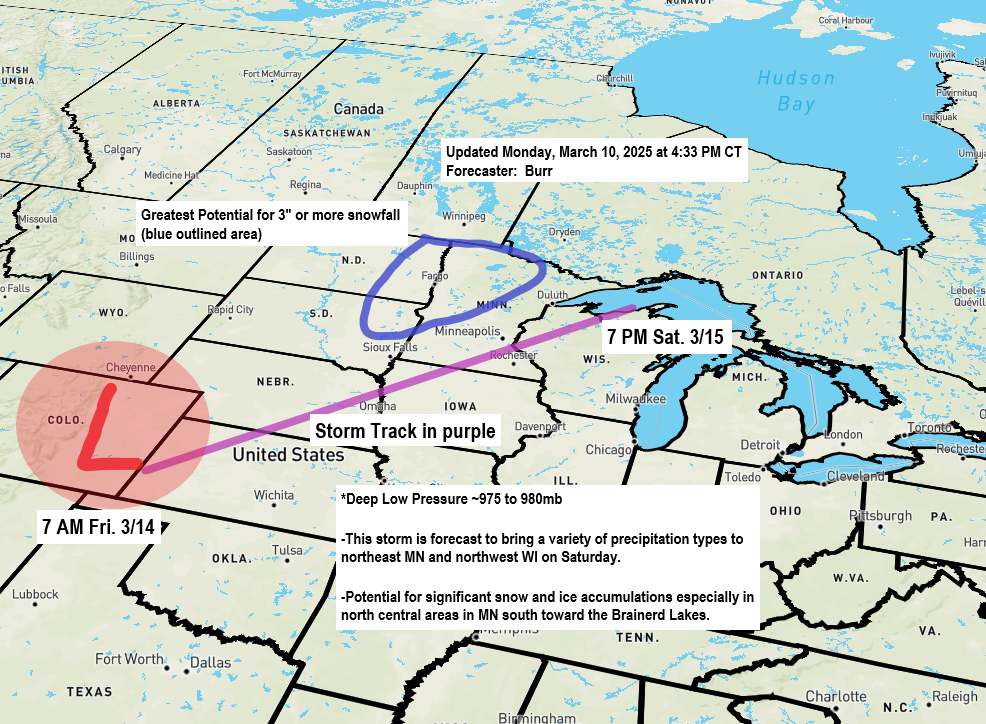
A low pressure system of about 975 to 980mb is expected to form over eastern Colorado or Kansas on Friday morning. It will move northeast, passing through southern Minnesota and western Wisconsin on Saturday, and reaching western upper Michigan by Saturday evening. Note: There is still some uncertainty regarding the path of this low, but it is decreasing.
Liquid Equivalent (Rain + Snow) Precipitation Forecast
Precipitation totals of around half an inch to an inch are possible in the Northland from Friday into late Saturday night.
NWS Blend of Models forecast

Freezing Rain/Ice Potential
There is a chance for some impactful amounts of ice from freezing rain on Saturday in western portions of the Northland, or west of that black line on the map.

Here’s the Euro ensemble model probability for ice accumulation of greater than 0.1″ for Saturday ending at 7 PM.
Higher chances to the west, lower chances to the east.

Snow Potential
The best chance for 3 or more inches of snow on Saturday is in north central and western Minnesota and the eastern Dakotas. This area may shift slightly east or west in the coming days. Stay tuned for updates.

Temperature Change
Much colder air is forecast to move into the Northland from west to east on Saturday, with temperatures in Duluth forecast to be in the lower 40s during the day, falling to the middle 20s by early Saturday evening and to the teens by Sunday morning.
How quickly the cold air arrives on Saturday is still uncertain and will help determine how much frozen precipitation we see in Duluth Saturday afternoon/night. If the cold air is delayed, then we might not see much snow or mixed precipitation in Duluth on Saturday, but if the cold air moves in quicker, then some snow and potentially some ice accumulation are possible.


Thunderstorm Potential Friday
Here’s the National Weather Service Blend of Models thunderstorm potential from 7 AM Friday to 7 AM Saturday.
Higher chances for thunderstorms in green, but even if your part of the state is in the green, it doesn’t guarantee you’ll get a thunderstorm Friday or Friday night.

Wind
We are looking at the potential for some strong winds in the Northland Saturday into Sunday morning, with gusts possibly exceeding 30 to 40 mph. Winds will be out of the north or west.
Breezy southerly winds are also expected on Friday with gusts to 25 mph in parts of the Northland.
Note: An east gale event doesn’t look very likely at the moment with this storm on western Lake Superior, but gusty east winds of up to 30 mph could occur Friday night into Saturday morning.
Euro model wind gust forecast from 7 AM Saturday to 7 PM Sunday.

Severe Thunderstorm Outlook
There is a risk of severe thunderstorms Friday and Saturday south of our area, with all hazards possible, including damaging winds, large hail, and some tornadoes.
Friday’s Outlook

Saturday’s Outlook

Thanks for reading!
Leave a Reply to Timothy BurrCancel reply