6:43 PM Friday, March 21, 2025
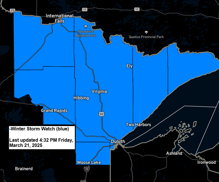
A winter storm watch is in effect from late Saturday night through Sunday evening for parts of northeast Minnesota, including the North Shore and Arrowhead. It is likely that the National Weather Service will upgrade this winter storm watch to either an advisory or a warning sometime on Saturday.

Snowfall totals in Duluth with the system on Sunday should fall within the range of our top three greatest daily snowfall totals observed this winter. Whether or not it can surpass 4.8 inches remains uncertain; however, the chances appear to be quite low at this time.
Top 3 highest daily snowfall totals this winter in Duluth
1: 4.8 inches on January 12th
2: 4.2 inches on February 1st
3: 3.4 inches on February 14th
Note: One of the fail mode models for the system on Sunday would be the HRRR model, which shows the low crossing northern Minnesota. This would really cut down on the amount of snow we’d see in Duluth should the system take a track the HRRR model is showing today, so there’s still some uncertainty with this system.
Also of note, the average date for Duluth’s last snowfall of 1 inch or more is April 12th, but the latest recorded date is May 19th (2019).
Here’s my updated Snowfall Forecast as of late Friday afternoon
- *Greatest amounts that could reach 5 to 8 inches are possible along the North Shore of Lake Superior due to the possibility of some lake/terrain-enhanced snow with the east winds crossing Lake Superior in combination with the snow from the low-pressure system.
- *1 to 3 inches of snow in far southern areas, where we could see more of a mix of rain and snow on Sunday
- *Elsewhere, a range between 3 and 5 inches of snow is possible.
Note: Changes in snowfall amounts are possible over the next 24 hours. Check back for updates.

Here’s a closer look at potential snowfall totals for the Duluth metro area on Sunday.
Greatest amounts in higher elevation with around 5 inches of snow with generally 2 to 4 inches of snow in lower elevation closer to Lake Superior.
Note: One thing that may lead to greater snow totals in Duluth on Sunday would be more intense lift, leading to higher snowfall rates and more rapid snow accumulation during the day, which would offset the warming effects of the sun angle at this time of year.
Updates to this forecast are possible over the next 24 hours.

Light Ice Accumulations Possible early Sunday morning
The initial round of precipitation, which is forecast to spread northeast across the Northland late Saturday night/early Sunday morning, could fall as some freezing rain or sleet, with some patchy ice accumulations of a light glaze to around 0.05 inches possible early Sunday morning.

All is good with the weather during the day Saturday, but it will be a cold start to the day with temperatures ranging from around 12 below zero to 10 above in the Northland, with the coldest temperatures in northern Minnesota.
Precipitation is forecast to begin Saturday night, spreading northeast across the Northland.
Note: Around 1 to 3 AM Sunday morning is when precipitation is expected to start in Duluth. Precipitation is expected to diminish Sunday evening and overnight.
NAM 3km model simulated radar forecast valid 7 PM Saturday to 1 AM Monday.

Here’s an updated forecast regarding the track of the low this weekend.
Ensemble model guidance has tightened up considerably with the track of the low, although the GEFS or American model remains a little farther north with the track of the low, which is shown in yellow on the map below.
Computer models used in this forecast include
EPS (euro ensemble) 51 total members
GEFS 31 total members
CMCE (Canadian ensemble) 21 total members
MOGREPS-G (UK ensemble model) 18 total members

As the mid and upper-level system approaches from the Dakotas, it is forecast to deepen, which should enhance the amount of lift in the atmosphere and lead to precipitation production in the Northland late Saturday night through Sunday evening.
NAM model 500mb vertical velocity forecast valid 7 PM Saturday to 1 AM Monday.

Thanks for reading!
Leave a Reply