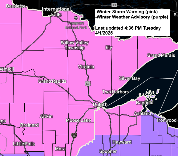
6:10 PM Tuesday, April 1, 2025
Winter storm warning is in effect for all of northeastern Minnesota and far northwestern Wisconsin from tonight through Wednesday evening, with a winter weather advisory in effect for the southeastern portion of northwestern Wisconsin.

For the Duluth area
-Snow begins late tonight between 11 PM and 1 AM. Up to 2 inches of snow accumulation are possible by 7 AM Wednesday.
-The worst part of this storm is forecast to hit during the day Wednesday with strong northeast winds gusting 25 to 45 mph, along with snow and possibly some sleet and freezing drizzle at times. Heavy snow with rates of a half inch to nearly an inch per hour could occur at times on Wednesday.
-The combination of the strong northeast wind and falling snow could lead to brief whiteout/near whiteout conditions, especially when the heavier bands of snow move through on Wednesday.
-Snow tapers off Wednesday night.
NAM 3km model simulated radar forecast through 12 PM Thursday.
Snow – blue
Rain – green
Mix – purple

Here’s my updated snowfall forecast as of late Tuesday afternoon.
- North Shore should receive the greatest amounts, which will range between 10 and 18 inches. This is due to east winds crossing Lake Superior, which should cause some lake/terrain-enhanced snow Wednesday into Wednesday evening.
- Far southeastern portions of northwest Wisconsin from around Spooner and Hayward to the Ashland area will see lower snow amounts (1-3 inches) due to mixing issues on Wednesday.
- Much of the rest of the area can expect 5 to 8 inches of snow, with some locally higher amounts surpassing 8 inches possible.
Duluth: 8 to 10 inches of snow are possible by Wednesday evening. Snow amounts could end up lower than this if a dry slot works into the city or if we see more of a mix of precipitation types on Wednesday. Both are possibilities due to the different storm tracks the computer models continue to show today.
Note: The most snow ever recorded in Duluth on April 2nd is 6.2 inches from 1950. This record might be broken on Wednesday.

Ice Accumulation Forecast
Some patchy freezing rain/freezing drizzle is possible on Wednesday, especially over northwest Wisconsin and eastern Minnesota, with ice accumulations of a light glaze up to 0.05 inches possible, but a significant ice storm is not expected with this storm.

Thunderstorm Potential
There might be a few thunderstorms on Wednesday, mostly in northwest Wisconsin and far eastern Minnesota, with less chance to the north, including Duluth and the North Shore. No severe weather is expected in our area on Wednesday.

A strong low-pressure system of about 986mb/29.12 inches is located over western Kansas, near Garden City late this afternoon, and is expected to move northeast, reaching northern Iowa by 1 PM Wednesday and northern Wisconsin between Ashland, WI and Ironwood, MI by 7 PM Wednesday. Note: There is some uncertainty in the track of this low, as some models suggest it may move slightly farther west while others indicate a more southern or eastern path.

A 500mb analysis shows a large trough over the northern and central Rockies this afternoon. This trough will move east and become stronger as it reaches the upper Midwest on Wednesday.

This will probably be another strong spring storm, which we’ve seen many times in the last month.
Strong winds high in the atmosphere are occurring south of a trough moving down through the Rockies today. As this trough moves into the upper Midwest on Wednesday, it may tilt slightly negative.

Goes-16 infrared satellite loop ending 5:36 PM CT Tuesday, April 1, 2025.

Thanks for reading!
Leave a Reply