5:17 PM Wednesday, April 2, 2025
Based on the snow reports that have come in today, it’s looking like this will be another failed snowfall forecast for Duluth and possibly in other parts of the Northland as well. However, with snow ongoing late this afternoon, we will see what we end up with for totals come early Thursday morning. I will have a detailed analysis of this storm on Thursday, including final snowfall totals and comparing them to what was forecasted. Always interesting.
Duluth: Wet snow continues tonight along with some drizzle and patchy fog. Additional snowfall accumulations between a trace and 2 inches. Northeast winds gusting 25 to 45 mph will shift to the northwest late tonight. Temperatures will range from around 27 to 31 degrees tonight.
HRRR model simulated radar forecast through 7 AM Thursday.

Additional snowfall accumulations for tonight according to the HRRR model.

Northland Snowfall Reports as of 4 PM Wednesday, April 2, 2025
Leader, MN: 6.0″
7 WNW Hackensack, MN: 4.2″
Duluth, MN: 3.7″ (official total at the NWS)
7 WSW Hovland, MN: 3.0″
Cass Lake, MN: 3.0″
2 S Emily, MN: 2.8″
6 W Washburn, WI: 2.7″
2 SW Hinckley, MN: 2.5″
Brule, WI: 2.0″
3 E Orr, MN: 1.5″
Ashland, WI: 1.0″
Solon Springs, WI: 1.0″
-Blizzard Warning until 10 PM tonight for the North Shore of Lake Superior including Two Harbors, Silver Bay and Grand Marais.
-Winter Storm Warnings and Advisories continue for the rest of northeast Minnesota and for parts of northwest Wisconsin tonight.


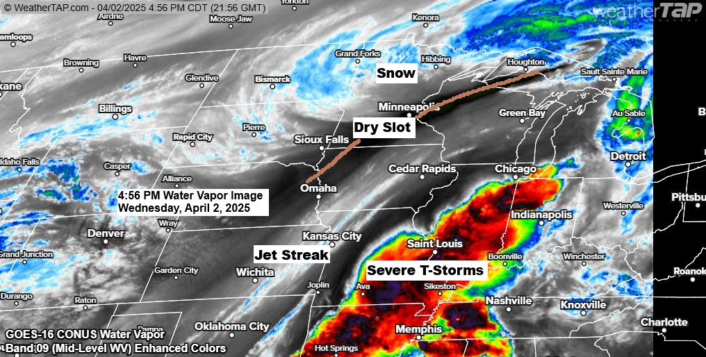
A strong area of low pressure was centered southwest of Minneapolis, MN late this afternoon. This low will continue to lift northeast as it passes near or a little west of Houghton, MI early Thursday morning.

The northern part of the spring storm is bringing snow and strong winds from the eastern Dakotas to north central and northeast Minnesota today

While the southern part of this spring storm is producing widespread showers and thunderstorms capable of producing tornadoes (some strong ones), large hail, and damaging winds.

And here’s a loop of the radar from this afternoon.
Red polygons – Tornado Warning
Yellow polygons – Severe Thunderstorm Warning
Green polygons – Flash Flood Warning
Radar loop ends 4:24 PM CT Wednesday, April 2, 2025.
Several tornado watches, including one PDS tornado watch, are in effect into this evening.

Goes-16 infrared satellite loop ending 3:59 PM CT Wednesday, April 2, 2025.
Here’s another satellite loop (enhanced water vapor) of today’s spring storm with the loop ending at 4:51 PM CT Wednesday, April 2, 2025.

One cold pocket across the upper Midwest today, but check out the temperatures farther to the south, where we’re seeing widespread 70s and 80s this afternoon.

Thanks for reading!
Leave a Reply