6:27 PM Thursday, April 24, 2025
Showers and thunderstorms are expected early next week in northeast Minnesota and northwest Wisconsin. Some storms, particularly on Monday, may be strong to severe, especially in east central Minnesota, including the Brainerd Lakes area, Duluth, and all of northwest Wisconsin.
There is uncertainty in the computer models about when this system will arrive and how strong the upper trough will be as it moves out of the Rockies early next week. However, we are expecting a good chance of rain and some thunderstorms in much of the Northland early next week. Whether these storms will be severe next Monday depends on factors such as moisture and instability in the area, as well as the timing of the system.
Stay tuned for updates the next few days.
The Storm Prediction Center’s updated severe weather outlook for next Monday, April 28, shows a risk of severe thunderstorms in the yellow and orange areas, with the highest risk in the orange area.

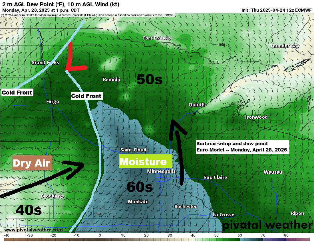
The surface setup for next Monday features an area of low pressure anticipated to be over South Dakota on Monday morning, accompanied by its warm front and cold front. This system is expected to track northeastward, while a separate cold front located farther northwest is forecast to move toward the east-southeast.

The upper trough over the Rockies next Monday morning is expected to move northeast, but some model data suggests it may weaken just a bit as it exits the Rockies, so this is something to watch in the coming days.

Forecast temperatures for next Monday vary across the region, ranging from 80s in southwest Minnesota to 60s in the north, with cooler temperatures near Lake Superior due to east winds.
If the warm air materializes in southwest Minnesota, it could contribute to an elevated mixed layer (EML enhancing mid-level lapse rates and potentially aiding these storms on Monday in becoming efficient lightning and hail producers across the Northland.

Tonight, a system is passing mostly south of the Northland, but the northern edge of this system will bring some rain to portions of northwest Wisconsin, while the rest of the Northland, including Duluth, should stay dry tonight.
Radar loop ends 6:03 PM Thursday, April 24, 2025
Here’s a look at the NWS Blend of Models total rainfall through 7 AM Friday.

Goes-16 water vapor loop ending 5:52 PM CT Thursday, April 24, 2025.

Thanks for reading!
Leave a Reply