5:55 PM Wednesday, May 28, 2025
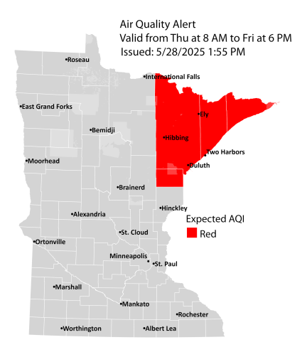
An air quality alert (red area on the map) is in effect from Thursday morning at 8 AM through late Friday afternoon at 6 PM for northeastern Minnesota. Dense smoke from Canadian wildfires in southeast Manitoba is expected to move southeast into northeastern Minnesota starting Thursday morning. On Friday, a second wave of heavy smoke from several large wildfires in Manitoba and Saskatchewan is anticipated to be carried south into Minnesota following a cold front.
Will finally get a wind shift to the northwest in Duluth for Thursday and most of Friday, which will help boost temperatures well into the 70s, even near Lake Superior. However, an east wind looks to return sometime late Friday afternoon or evening, and that east wind may persist into the weekend. If it does, then temperatures will be in the 50s within about 10 miles of Lake Superior both Saturday and Sunday, while inland temperatures reach into the 70s and maybe even a few 80s over the weekend.
Note: Today, Wednesday, May 28th, marked the first instance since May 15th of above-average temperatures in Duluth. Additionally, the high of 70°F today marked the first time reaching 70°F since May 15th, which recorded a high of 77°F.
Isolated showers may occur in the Northland on Thursday and Friday, but most of us are expected to remain dry.
An increased likelihood of showers and potentially some thunderstorms is expected next week as the weather pattern becomes more dynamic
HRRR model smoke forecast valid 7 AM Thursday to 1 PM Friday.
Denser smoke appears in orange, red, and purple colors on the loop below. Some of this smoke may reach the surface by Thursday afternoon through Friday.

Smoke is seen on satellite images today over central Canada, and it will move south into the Northland on Thursday.

Here’s a loop of the above image ending at 3:50 PM CT Wednesday, May 28, 2025.

24-Hour Rainfall Reports as of 5:30 PM on May 28, 2025.
- Spooner, WI: 0.15″
- Solon Springs, WI: 0.08″
- Brainerd, MN: 0.06″
- Minong, WI: 0.04″
- Grand Rapids, MN: 0.03″
- Hill City, MN: 0.03″
- Moose Lake, MN: 0.02″
- Hayward, WI: 0.02″
- Poplar, WI: 0.02″
- Cable, WI: 0.02″
- McGregor, MN: 0.01″
- Ashland, WI: 0.01″
- Winter, WI: 0.01″
- Danbury, WI: 0.01″
Showers that have been scattered throughout the Northland today should end by late this evening.
Radar loop ends 5:28 PM CT Wednesday, May 28, 2025.
The pattern continues to be very blocky today, with a few upper-level lows and upper-level ridges across Canada and the U.S. This pattern will finally begin to break down a bit, especially as we get to next week.

Goes-16 water vapor loop ending 4:10 PM CT Wednesday, May 28, 2025.

Here’s a look at rainfall expected through Saturday, June 7th, according to the NWS Blend of Models. Most of the rain will fall next week, possibly reaching an inch or more in parts of northeast Minnesota and northwest Wisconsin.

Thanks for reading!
Leave a Reply