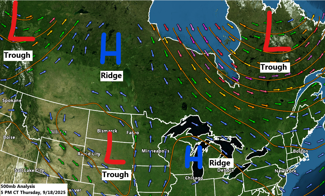
The pattern remains significantly amplified, which is somewhat unusual for this time of year.
Three troughs with lower 500mb heights are noticeable: one in northwest Canada, another in eastern Canada, and the last over the northern and central Plains. Meanwhile, an upper-level ridge with higher 500mb heights is present to our northwest and to our east today.
The trough over the northern and central Plains will slowly move east-northeast through the weekend, eventually bringing some rain to much of the Northland.
Goes-16 water vapor loop ending 5:45 PM CT Thursday, September 18, 2025.

Two out of the three things in today’s forecast have come true.
First, temperatures are cooler, and second, the wind has been gusty, especially near Lake Superior. However, the third element, rain, hasn’t really made an appearance yet.
Temperatures today were 5 to 20 degrees cooler than yesterday in northeast Minnesota and northwest Wisconsin, with the most significant drop near Lake Superior because of a stronger northeast wind compared to yesterday.

This afternoon, temperatures were mainly in the upper 50s and 60s across northeast Minnesota and northwest Wisconsin, with warmer 70s further south.

Winds have been quite gusty today, with peak gusts reaching 37 mph at Duluth Sky Harbor Airport and ranging between 25 to 30 mph in other areas of Duluth.
Strong northeast winds will persist in the Twin Ports area until Saturday morning, with gusts ranging from 20 to 35 mph.

Intermittent rain is forecasted for the Northland tonight and Friday, with dry intervals scattered throughout.
This is the NAM 3km model’s simulated radar forecast up to 7 PM on Friday.

Occasional scattered showers will persist in the Northland throughout Saturday and Sunday, but neither day is expected to be a total washout.
Various computer models continue to forecast rainfall totals of around half an inch or more in Duluth by 7 AM Sunday, while the GEFS model predicts lower amounts, staying below half an inch.


Leave a Reply