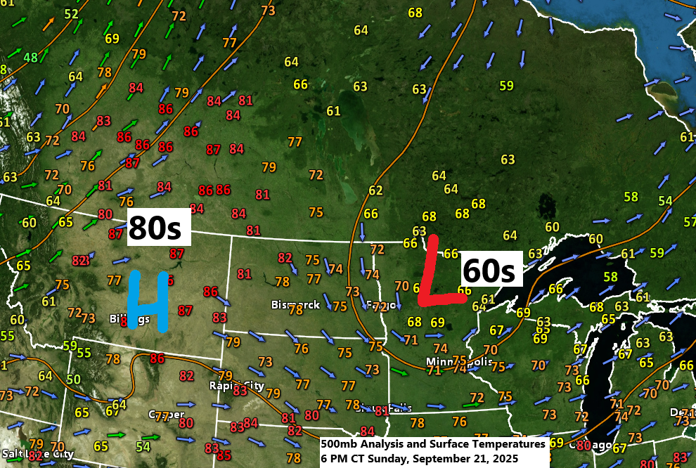
The weather pattern today remained consistent, with an upper trough/low over the upper Midwest and an upper-level ridge across the northern Rockies. Temperatures this afternoon ranged from the 60s to around 70 under the trough in northeast Minnesota and northwest Wisconsin, while the northern Rockies enjoyed warmer 80s under the ridge.
More fog is expected in parts of the Northland, including the Twin Ports, tonight and lingering into Monday morning. Visibility may drop to less than a mile in the darker-colored areas shown on the loop below.
Looks like another round of fog is expected to settle in on Monday night.
HRRR model visibility forecast until 1 PM on Monday.

This afternoon, scattered strong and severe thunderstorms have developed in southern Minnesota, with a few reports of large hail measuring between 1 and 2 inches in diameter.
Scattered showers have been observed in northeast Minnesota and northwest Wisconsin today, and a few are expected to persist overnight and into Monday. However, the coverage is likely to diminish gradually.
The radar loop concludes at 7 PM on Sunday, September 21, 2025.
The Northland is transitioning into a drier pattern this week, lasting through next weekend.
As the current upper trough moves east on Monday, a ridge from the northern Rockies will expand eastward for the rest of the week. Meanwhile, the wet weather will shift much farther south, linked to a trough over the Midwest.

Over the last three days, Duluth has seen rainfall ranging from half an inch to just over three-quarters of an inch, with 0.65 inches measured at the airport and 0.88 inches in Hermantown.
In other parts of Duluth, rainfall over the past three days has ranged from 0.43 to 0.55 inches.

Take a look at the European model’s total precipitation forecast for the Midwest and Ohio Valley, valid through 7 PM Friday.
Once again, this upcoming upper-level system will not impact northeast Minnesota or northwest Wisconsin in the coming days.

Leave a Reply