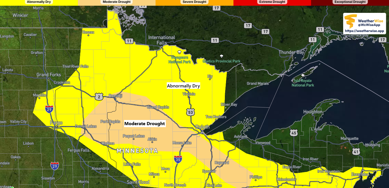
This week’s drought monitor update shows an increase in moderate drought and abnormally dry conditions.
There are a couple of rain chances ahead, but none of them look to bring significant amounts of precipitation to the Northland, at least through early next week.
Duluth has seen nearly 8 inches less precipitation than normal since January 1st, and is nearly 2 inches below normal since September 1st. Meanwhile, International Falls is 3.69 inches below normal in precipitation since January 1st and 2.31 inches below normal since September 1st.
It’s been dry lately, with rainfall in the last 30 days only 25 to 50% of normal in the dark red areas on the map.

The soils are quite dry across much of northeast Minnesota and northwest Wisconsin, particularly in the areas highlighted in red and orange on the map.
Data as of October 8, 2025.

12% of Minnesota is currently in moderate drought, an increase from 3% last week.
Minnesota’s abnormally dry conditions have increased to 57%, a significant jump from 34% just last week.

6% of Wisconsin is now in moderate drought, up from 0% last week.
Sixty-nine percent of Wisconsin is now facing abnormal dryness, a sharp rise from 35% just the week before.

Tonight, scattered showers will sweep through parts of the Northland, mostly before midnight, as a cold front moves through the area. Meanwhile, low pressure from Manitoba will drop southeast, passing over or near the eastern half of Lake Superior by Friday.

Scattered showers in central Minnesota will keep moving quickly to the east this evening, but it seems unlikely that we’ll get much rain from this system.
The radar loop concludes at 6:10 PM CT on Thursday, October 9, 2025.
A strong system is expected to move northeast out of the Rockies this weekend, though much of its energy will likely pass northwest of the Northland. However, some showers are still anticipated in our area on Sunday as another cold front pushes through.

This weekend’s system will bring snow to parts of the northern Rockies and possibly western North Dakota. Meanwhile, the upper Midwest will stay on the milder side, with no snow expected in that area.

An overview of the snowfall forecast through Monday morning based on the European computer model.

By early next week, northeast Minnesota and northwest Wisconsin could see about 0.1 to 0.25 inches of rain, including the impact of tonight’s front and the system moving in on Sunday.

Leave a Reply