Lots of wind across the area today.
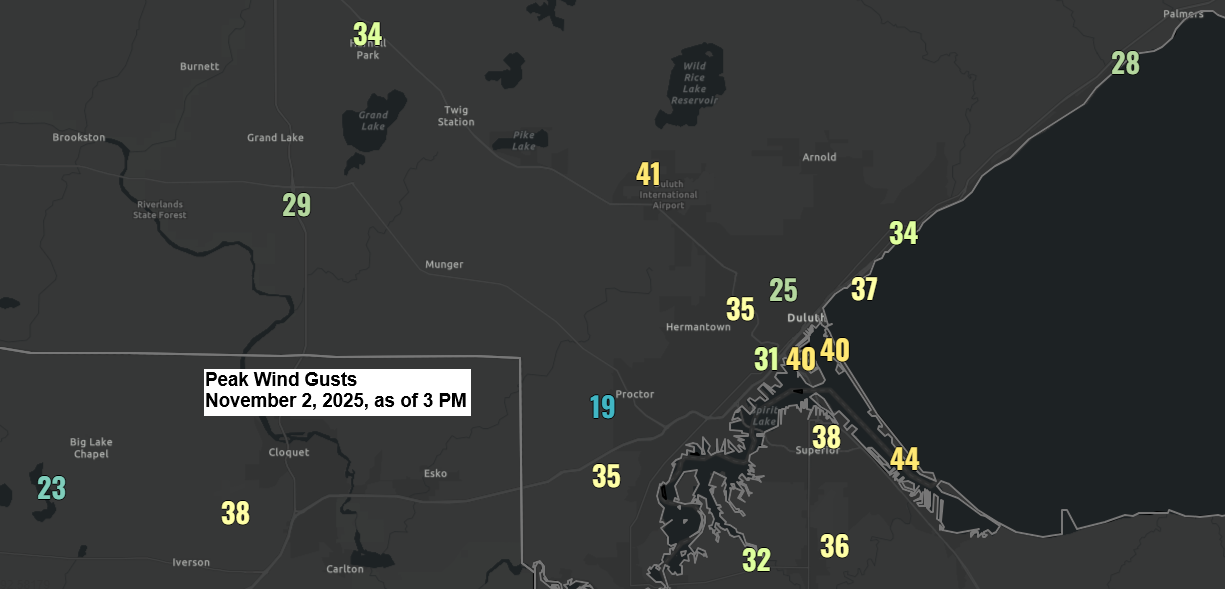
Wind gusts in the Twin Ports have peaked at 44 mph at Duluth Sky Harbor Airport, 41 mph at Duluth Airport, and 36 mph at Superior Airport.
In other areas in northeast Minnesota and northwest Wisconsin, wind gusts have ranged from around 25 to 40 mph today.

A strong low-pressure system, measuring approximately 987mb or 29.15 inches, was situated over northwest Ontario this afternoon and is expected to continue tracking northeast tonight.
The strong pressure gradient in the region will stick around through tonight and Monday, bringing gusty winds. The change from warm air advection to cold air advection will help keep the winds going through Monday. Gusts between 20 and 40 mph are expected to continue across northeast Minnesota and northwest Wisconsin during this time.
Temperatures are quite mild for early November, with 40s to around 50 degrees this afternoon in northeast Minnesota and northwest Wisconsin, while parts of South Dakota and Nebraska are enjoying 70s and lower 80s.

One of the major stories today is the exceptionally strong jet stream extending from southwest Canada to the northern Plains, with speeds reaching an impressive 130 to 170 knots or 150 to 200 mph.

Goes-19 water vapor loop ending 3:50 PM CT Sunday, November 2, 2025.

Today’s system has brought a few sprinkles and light showers to the Northland, and this spotty light precipitation will persist into this evening, with dry weather overnight and on Monday.
Radar loop ends 4:10 PM Sunday, November 2, 2025.
In the week ahead will have a system cross the area late Tuesday-early Wednesday bringing a few showers to the Northland.
Later this week, one or two clipper systems might impact the Northland, potentially bringing rain and possibly some snow. However, just like 24 hours ago, there remains significant uncertainty regarding the timing, track, and type of precipitation that could occur if a system does affect the area.
Leave a Reply