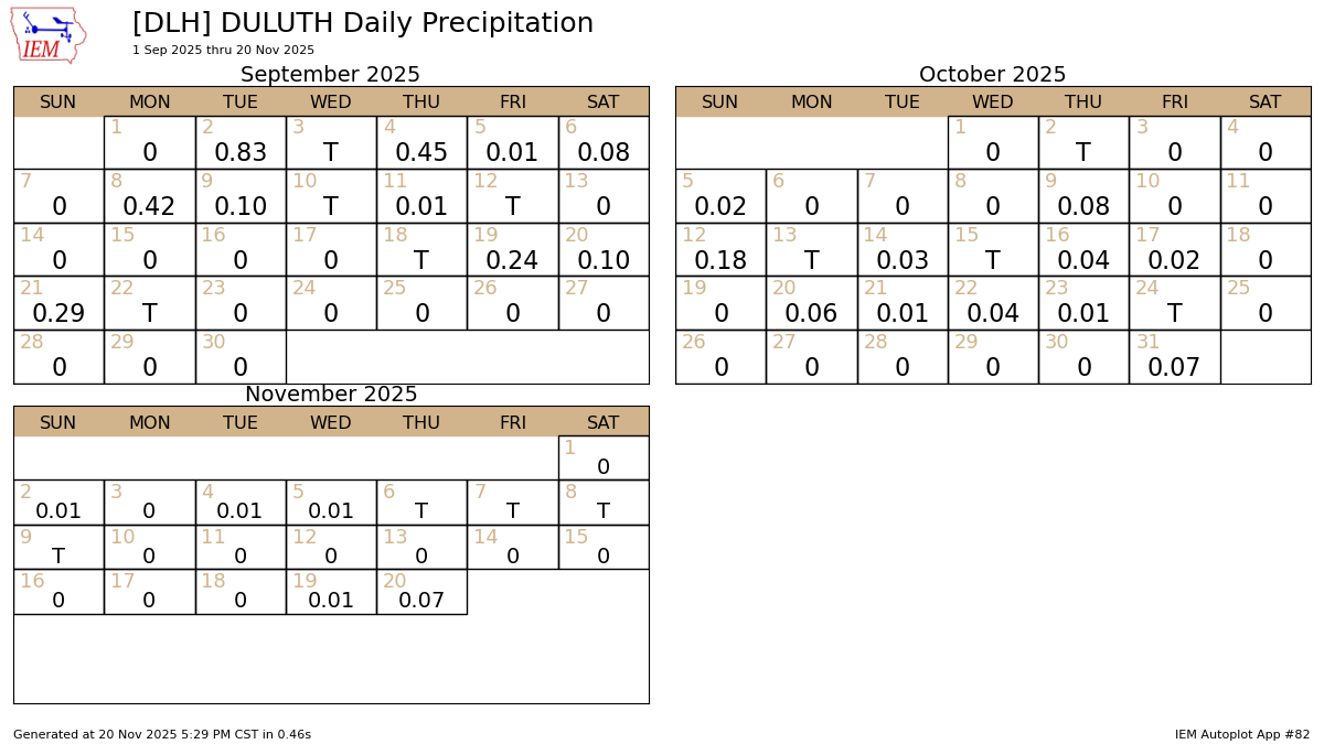
After the rainfall last night and today, November 2025 in Duluth won’t end up as the driest on record. That honor still goes to 1917 and 1916, when just 0.09 inches of precipitation fell. So far this month, through the 20th, Duluth has received 0.11 inches of precipitation.
Duluth saw 0.07 inches of precipitation today (Nov. 20), the highest daily total this month, tying the amount recorded on Halloween (Oct. 31).
Duluth hasn’t had a quarter inch or more of precipitation since September 21st. That dry spell might break by mid-next week, but we’ll have to wait and see.
Duluth still hasn’t had its first 1-inch snowfall of the 2025-2026 season. Typically, this happens by November 4th, but the latest on record was December 5th in 2008. That winter ended with a below-average total of 73.6 inches of snow, though December 2008 was especially snowy, with 37.1 inches falling that month.
You have to go back to 2013 to find a later date than what we’re seeing now for the first one-inch snowfall in Duluth. That year, it happened on November 27th. Interestingly, the 2013-14 snow season ended up well above average in Duluth, with a total of 131 inches.
I’m watching a system expected around the middle of next week that could bring rain and a chance for some accumulating snow to northeast Minnesota and northwest Wisconsin.
The exact path of this system is still changing in computer models and will probably keep shifting over the next few days. It could slide farther south and east, potentially bringing accumulating snow to much of the Northland from late Tuesday into Wednesday (November 25-26). At first, the airmass should be warm enough for rain to begin Monday night or Tuesday, but as the system moves away, northwest winds will strengthen, colder air will push in, and if enough moisture remains, snow could develop Tuesday night into Wednesday. Stay tuned for updates.

Here’s a look at the ensemble model’s total precipitation forecast through 6 PM on Wednesday, November 26, 2025.
The Euro and Canadian ensemble models are predicting higher precipitation totals in northeast Minnesota and northwest Wisconsin than the GEFS model for next Tuesday and Wednesday, with amounts around half an inch or more. The GEFS model, on the other hand, shows about 0.3 to 0.4 inches. Some of this could come down as snow, and if these amounts pan out, there’s a chance of at least a couple inches of snow accumulation by Tuesday night into Wednesday.


Leave a Reply