The pattern seems to be waking up.
Looks like a cold and possibly stormy weather pattern could set in across the Northland by mid-next week and stick around for several days after.
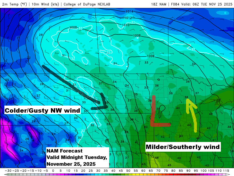
The first system is expected to arrive around Monday night or Tuesday next week, bringing some precipitation to northeast Minnesota and northwest Wisconsin in the early to middle part of the week.
At first, temperatures seem warm enough for rain, but colder air is expected to move in, turning the rain into snow sometime Tuesday afternoon or evening, with a chance of lingering snow Tuesday night and into Wednesday.
Computer models are still uncertain about how much precipitation, including snowfall, this system will bring, but one thing seems clear: colder air and gusty northwest winds will sweep into the Northland from Tuesday afternoon into Wednesday.

After Thanksgiving is when the real fun might start, but with the amount of variability in computer models over the past few days, anything they predict for next weekend should be taken with a big grain of salt.
Right now, there’s a chance the pattern could amplify with a trough out west and a ridge to the south and east, sending one or more low-pressure systems northeast from the Rockies. If this setup takes shape, snow or other types of precipitation would likely become more common in northeast Minnesota and northwest Wisconsin around November 29 to December 2, give or take. There’s also some potential for a very strong low-pressure system to track from the Midwest to the Great Lakes during that period.

It’s been since last winter that I’ve seen this much purple and other vibrant colors on a snowfall accumulation map from the GEFS ensemble model, showing projected snowfall totals through December 7, 2025.
Purple areas indicate snow totals of 6 inches or more, and only 5 out of 20 ensemble members fail to show at least that much in Duluth by December 7th. In other words, the chances are pretty high that Duluth could get over 6 inches of snow, if not more, by December 7th according to today’s forecast from the GEFS model.

Another clipper system could bring a bit of snow or rain to far northern Minnesota on Saturday, but whatever falls near the border isn’t expected to amount to much, whether it’s rain or snow.
Gusty winds will move in with this system, with speeds possibly reaching 15 to 30 mph across much of the Northland on Saturday afternoon and evening.
NAM-Nest model simulated radar forecast valid 6 AM Saturday to 6 PM Saturday.

Leave a Reply