Tonight’s clipper is moving in from the northwest, bringing snow that will spread east across much of northeast Minnesota and northwest Wisconsin this evening before tapering off overnight. As the snow wraps up late tonight, there’s a chance for some patchy freezing drizzle to develop.
Snow is expected to begin falling in Duluth around 7 to 8 PM this evening and taper off between 1 and 3 AM on Tuesday.
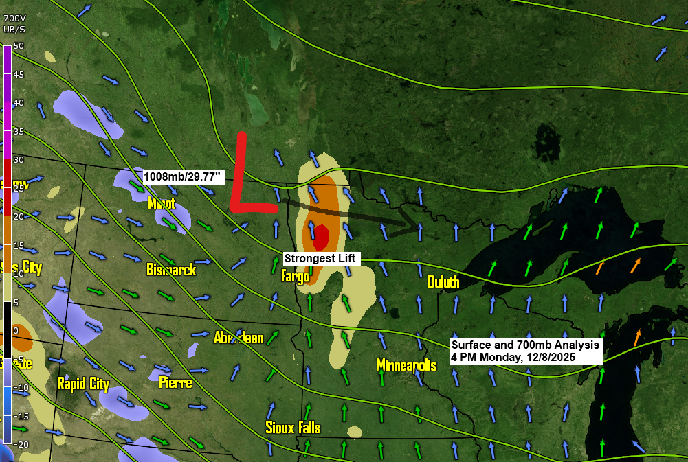
Radar loop ends 5:32 PM Monday, December 8, 2025.
Widespread snow totals of around 1 to 2 inches are expected across northeast Minnesota and northwest Wisconsin tonight, with some spots possibly seeing up to 3 inches.
Snow tonight is expected to last about six hours or so, with snowfall rates possibly reaching 0.5 to 0.75 inches per hour as stronger lift moves through parts of the Northland later this evening.
No updates to my snowfall forecast for tonight’s clipper.

…Tuesday’s system…
A stronger surface low, potentially dropping below 990mb or <29.23 inches, will move southeast out of southern Saskatchewan on Tuesday morning. It seems to be following a more southerly path, matching track number 2 from my post on Sunday.
With this more southerly track, the chances of Duluth getting several inches of snow have dropped, but some accumulation is still likely—unless the low shifts a bit further south, which could happen in the next 12 hours.

Snow looks to begin in Duluth late Tuesday afternoon or early evening around 5 to 7 PM and the snow looks to conclude early Wednesday morning before 4 AM.
RGEM model simulated radar forecast valid 12 PM Tuesday to 6 AM Wednesday.

Here’s my initial snowfall forecast for Tuesday’s clipper system.
Highest totals of 3 to 6 inches from Walker and Brainerd to Aitkin to Hinckley to Grantsburg and Siren, east toward Hayward.
From Bigfork and Hibbing to Silver Bay, only a dusting to an inch of snow is expected.
In between the highest and lowest amounts, including for Duluth, expect about 1 to 3 inches of snow the way it’s looking now.
Note: This forecast may be subject to changes, so keep an eye out for updates.

Widespread weather alerts have been issued for Tuesday as a clipper system moves through.
- Winter Storm Warning (pink)
- Winter Storm Watch (blue)
- Winter Weather Advisory (purple)
- High Wind Warning (orange)


Strong winds, with gusts of 35 to 60 mph or more, will hit the Dakotas on Tuesday and spread southeast into western and southern Minnesota later in the day and into Tuesday night. The winds will gradually weaken from northwest to southeast on Wednesday.
Blizzard conditions may develop from Tuesday into Wednesday morning across parts of the Dakotas and western to southern Minnesota, with strong winds likely to cause widespread blowing snow problems.
In northeast Minnesota and northwest Wisconsin, wind gusts of 15 to 30 mph are possible from Tuesday evening into Wednesday, creating areas of blowing snow.
HRRR model wind gust forecast valid 12 PM Tuesday to 12 PM Wednesday.

Leave a Reply