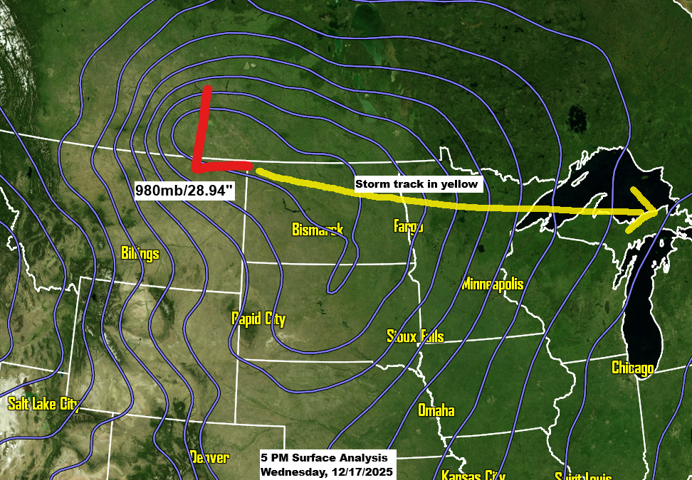
A strong low-pressure system over southern Saskatchewan this afternoon will move east-southeast, passing over far northern Minnesota Thursday morning before reaching eastern Lake Superior by around 6 PM Thursday.
Over the next 24 to 36 hours, this system will bring snow, rain, wind, and a burst of arctic air to the Northland, with a flash freeze caused by rapidly dropping temperatures between noon and 6 PM Thursday.
Here’s my snowfall forecast through 6 AM Friday.
The heaviest snowfall from this system is expected over far northern Minnesota and the Arrowhead, with lighter amounts expected farther south.
Duluth area: Up to an inch of snow by Thursday evening.
In northwest Wisconsin, most of the snowfall is expected late Thursday afternoon and continuing into the night.

Multiple winter weather alerts are set to take effect from late tonight and continue through Thursday.


Snow – blue
Rain – green
Mix – pink
NAM-Nest simulated radar forecast through 1 AM Friday.

A High Wind Watch is in effect for the North Shore of Lake Superior in northeastern Minnesota on Thursday night, with possible wind gusts up to 60 mph. These strong winds could knock down trees and power lines, leading to widespread outages. The watch will likely be upgraded to a High Wind Warning or Wind Advisory by early Thursday morning.
Other areas of the Northland could also be under a wind advisory on Thursday afternoon and evening.

Tonight, the Northland will be firmly in a warm advection pattern, with temperatures slowly climbing through the night thanks to a strong low-level jet, where 850mb winds could hit 50 to nearly 70 knots. Overnight, most areas will see temperatures holding in the 30s.

The height changes with this system are impressive over the northern Rockies today, showing 12-hour 500mb drops of 120 to 180 meters. These big shifts are expected to move into the upper Midwest by Thursday.

As the upper trough and low shift southeast across the upper Midwest on Thursday, snow squalls could pop up in northeast and east-central Minnesota as well as northwest Wisconsin in the afternoon. These bursts of snow may cause brief near-whiteout conditions, drop a quick 0.5 to 1 inch of accumulation, and bring along some gusty winds.

Goes-19 water vapor loop ending 6:10 PM CT Wednesday, December 17, 2025.
Patchy freezing rain could develop over parts of the Northland overnight into early Thursday, with a thin layer of ice possible in the green-shaded areas on the map.

Around noon on Thursday, temperatures across the Northland will likely vary widely from northwest to southeast, ranging from about 10 to 15 degrees near International Falls to around 30 to 35 degrees in Duluth and throughout northwest Wisconsin.
Cold, arctic air will push quickly southeast out of western and northern Minnesota Thursday afternoon into the early evening, with temperatures in Duluth expected to drop to around 4 to 8 degrees by 6 PM.
Widespread temperatures in the teens and 20s below zero are expected across northeast Minnesota and northwest Wisconsin by Friday morning.

Leave a Reply