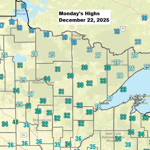
Milder weather made a comeback in the Northland today, with highs in the upper teens across extreme northern Minnesota near the Ontario border, and 20s to low 30s elsewhere. Overall, most spots were about 2 to 10 degrees warmer than normal for December 22nd.
Cooler weather will return on Tuesday, bringing gusty northwest winds of 15 to 30 mph. Northern Minnesota can expect temperatures in the single digits and teens, while the rest of the area will see temps ranging from the teens to the 20s.
Far northern Minnesota might see some snow or a bit of a wintry mix tonight, with less than an inch expected and little to no icing. Duluth, however, should stay free of snow or mixed precipitation tonight.
HRRR model simulated radar forecast through 7 AM Tuesday.

Later this week, from Christmas Day through Friday morning, another system is expected to move across the region. It could bring more snow or a mix of precipitation to parts of northeast Minnesota and northwest Wisconsin. While it doesn’t appear to be a major system, light snow and minor ice accumulations are possible later in the week. Stay tuned.
Leave a Reply