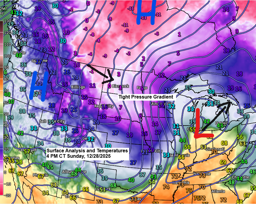
Today’s storm has unfolded pretty much as expected, with a noticeable sharp cutoff to the northern edge of the snow this afternoon.
So far today, Cloverdale, Minnesota, just east of Hinckley, has seen 4 inches of snow, while Brainerd, Minnesota, has received 3 inches, and 3 inches of snow has also been reported in Gordon, Wisconsin.
By 4 PM today, the National Weather Service in Duluth, Minnesota, had recorded 1.1 inches of snow, with another inch or so expected this evening. The snowflakes have been on the smaller side this afternoon, so accumulation has been slow, but strong winds are blowing the snow around, and that will remain an issue tonight and into Monday morning.
No further updates will be made to my snowfall forecast issued earlier today, which is available in my previous post.
Windy conditions will persist into Monday, with occasional bursts of blowing snow that may briefly create near-whiteout conditions, particularly near Lake Superior.
Strong winds near Lake Superior, especially along the North Shore, could lead to a few power outages tonight and into Monday.
Heavy snowfall rates of about 0.5 to 1 inch per hour will keep impacting parts of northwest Wisconsin mostly before midnight, though they might stick around past midnight along the South Shore of Lake Superior near and east of Ashland.
Snow will taper off from NW to SE later tonight, with the snow expected to wrap up in Duluth and Superior between 9 PM and Midnight.
HRRR model simulated radar forecast ending 6 AM Monday.

…Road Conditions…
Travel isn’t recommended in many parts of southern Minnesota (marked in purple on the map) because of whiteout conditions.


Colder air will keep moving east across the Northland tonight, with temperatures in Duluth falling into the teens this evening and dipping to about 5 degrees by 6 AM Monday.
On Monday, daytime temperatures will hover in the single digits to low teens across northeast Minnesota and northwest Wisconsin.
NAM 3km model temperature forecast ending 6 PM Monday.

Windy conditions will continue in the Northland tonight and into Monday, with gusts ranging from 15 to 30 mph.
Near Lake Superior, winds could be even stronger, reaching 30 to 60 mph, with the Arrowhead in far northeast Minnesota seeing the highest gusts.
Winds will ease throughout the day on Monday, except along the North Shore of Lake Superior.
NAM 3km model wind gust forecast ending 6 PM Monday.

Strong winds and high waves are on the way for the Great Lakes tonight and Monday, with wave heights on southern Lake Superior, north of Marquette, MI, potentially reaching 20 to 25 feet by Monday morning.

A widespread storm is hitting many areas today, bringing snow (blue), ice and a wintry mix (pink), along with rain (green).
Radar loop ends 4:38 PM CT Sunday, December 28, 2025.
Today’s storm has sparked some intense thunderstorms across parts of Illinois and Indiana, with a tornado watch in place until 9 PM ET for southern and central Illinois, western and central Indiana, western Kentucky, and far southeastern Missouri.

Goes-19 water vapor loop ending 3:46 PM CT Sunday, December 28, 2025.

The mid-level system over eastern South Dakota will keep moving southeast this evening, then swing northeast as it passes over lower Michigan early Monday morning.

The mid and upper-level trough linked to today’s storm is quite impressive, with 12-hour 500mb height changes of 90 to 150 meters in parts of the central Plains and upper Midwest.

Make a one-time donation
Make a monthly donation
Make a yearly donation
Choose an amount
Or enter a custom amount
If you find my forecasts helpful, consider supporting the blog. Every contribution keeps this work going. Thank you!
Your contribution is appreciated.
Your contribution is appreciated.
DonateDonate monthlyDonate yearly
Leave a Reply