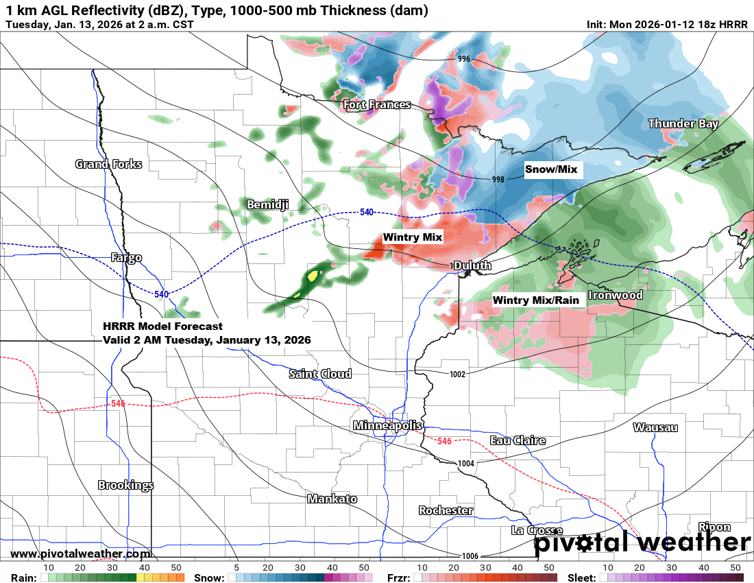
The next clipper will slide southeast across the Northland late tonight into Tuesday morning, bringing in warmer air along with a mix of snow, sleet, and some patchy freezing rain. While the precipitation should be light and short-lived, even a bit of freezing rain can make roads slick, so watch for slippery spots early Tuesday. Temperatures will climb above freezing during the day, helping to improve travel conditions.
HRRR model simulated radar forecast ending 7 AM Tuesday.

A winter weather advisory will be in effect late tonight into early Tuesday morning for parts of northeast Minnesota and northwest Wisconsin, with the possibility of a light mix of wintry precipitation and a thin glaze of ice.

An arctic front will move south behind the clipper, likely bringing scattered snow and mixed showers Tuesday afternoon, followed by a few flurries Tuesday night and heavier lake-effect snow in the snowbelt regions of northern Wisconsin.
NAM 3km model simulated radar forecast valid 10 AM Tuesday to 10 PM Tuesday.

…Snowfall forecast ending 6 AM Wednesday…
A light dusting to around an inch of snow is expected early Tuesday morning across parts of northeast Minnesota, while 1 to 3 inches are likely Tuesday night south and east of Ashland in northern Wisconsin, with the possibility of some locally higher totals.
Note: A third clipper is set to arrive late in the week, bringing snow across northeast Minnesota and northwest Wisconsin. It’s not expected to be a big storm, with only a few inches likely from Thursday afternoon into Friday.

…Windy weather Tuesday…
Gusty northwest winds are forecast from Tuesday through early Wednesday morning, with gusts possibly hitting 20 to 30 mph and occasionally reaching up to 40 mph.
HRRR model wind gust forecast valid 7 AM Tuesday to 7 AM Wednesday.

This winter’s weather pattern has been stuck, with a steady northwesterly flow bringing cold air to the upper Midwest, Great Lakes, and Northeast, while most of the rest of the country has enjoyed warmer-than-average temperatures since December 1st.
Note: There have been a few shifts in the pattern bringing occasional thawing across the upper Midwest and Northeast U.S., but they haven’t been enough to wipe out the below-average anomalies since December 1st.

With the persistent northwest flow we’ve had this winter, snowfall has been running below normal across much of the Northland, with most of the snow coming from clipper systems.
The exception has been in the lake-effect snowbelts of northern Wisconsin, where heavier snow events have popped up at times over the past few weeks.
It’s amazing—Juneau, Alaska saw 82 inches of snow in December 2025, setting a new record and coming in about 64 inches above the usual 18.1 inches. Looks like that area is getting most of the snow this winter.

Yellow and orange areas show below-average snowfall so far this season through January 11, 2026, while green areas are experiencing above-average snowfall.

It was another mild January day in northeast Minnesota and northwest Wisconsin, with highs in the 30s and even a few 40s.
No new daily records were set for January 12, but temperatures were still about 20 degrees warmer than normal for this time of year.
High temperatures for January 12, their departure from the average, and the record highs for today are listed below.
Brainerd, MN
High: 43
Departure: 22 degrees above normal
Record High: 48 set in 1986
Hibbing, MN
High: 40
Departure: 23 degrees above normal
Record High: 42 set in 1987
Ashland, WI
High: 39
Departure: 17 degrees above normal
Record High: 47 set in 1987
Duluth, MN
High: 38
Departure: 18 degrees above normal
Record High: 45 set in 1987
International Falls, MN
High: 38
Departure: 23 degrees above normal
Record High: 42 set in 1987
Note: A colder pattern is expected to set in by midweek and could stick around through the rest of January, with several bursts of arctic air likely moving across the Northland. How cold it will get is still uncertain, but nighttime temperatures in the teens and 20s below seem likely for now, and it could end up being even colder.

This afternoon, some areas in Duluth and Superior experienced temperatures in the low 40s.

Leave a Reply