With Duluth possibly hitting 30 below or even colder later this week, here’s a look back at the years since 1990 when temperatures that frigid have occurred in the city.
- 2021
- 2019
- 2004
- 1996
- 1994
Note: Last winter in Duluth, the lowest temperature was a frigid -27°F on January 21, with February 12 not far behind at -26°F. There were four days when lows dipped to -20°F or colder, with the average number of days with a low of -20°F or colder for an entire winter (DJF) being 6.
It’s looking like lows in the 20s to 30s below zero are pretty likely in northeast Minnesota and northwest Wisconsin on Thursday and Friday nights, with highs staying well below zero from Thursday through Saturday.
Note: There’s even a chance of hitting 40 below later this week in northern Minnesota.
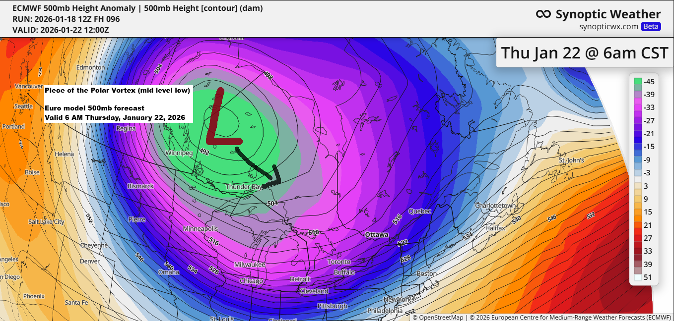
It’s not often you see 850mb temperatures, roughly 5,000 feet up, this frigid so far south. But the Euro model is calling for those temps to plunge to between -33 and -39°C Thursday night, which is pretty incredible and shows just how cold it could get later this week as part of the polar vortex slides south-southeast over Ontario.

…Cold Weather Alerts tonight into Monday morning…
Frigid tonight into Monday, with temperatures tonight plunging into the teens and 20s below zero across northeast Minnesota and northwest Wisconsin. Monday’s highs will range from around 10 below to 5 above zero. Northwest winds of 10 to 20 mph, with gusts up to 35 mph, will make it feel even colder, driving wind chills down to between 30 and 40 below from late tonight through Monday morning.

HRRR model wind chill forecast valid from 9 PM this evening to 8 AM Monday.
Note: The lowest wind chills in Duluth are forecast for Monday morning and could get as low as around -34 to -37 degrees.

Gusty northwest winds will bring areas of blowing snow tonight, causing significantly reduced visibility, especially in the advisory zones.

The North Shore of Lake Superior is under a wind advisory from late tonight until 6 AM Monday, with northwest gusts reaching up to 45 mph. Expect possible downed tree limbs and a few scattered power outages.

Additional snowfall accumulations between 1 and 4 inches are expected through Monday morning along the South Shore of Lake Superior, including the Bayfield Peninsula and locations around Hurley and Gile, with the higher amounts favoring the latter locations.
Note: By 4 PM today, Duluth had received 0.5 inches of snow with a snow-to-liquid ratio of just 12.5:1. A few more snow showers are expected this evening, with additional accumulations <0.5 inches.
Additional snowfall reports from Sunday, January 18, 2026, include 1.3 inches in Mahtowa, MN, and 1.1 inches in Hackensack, MN.

Leave a Reply