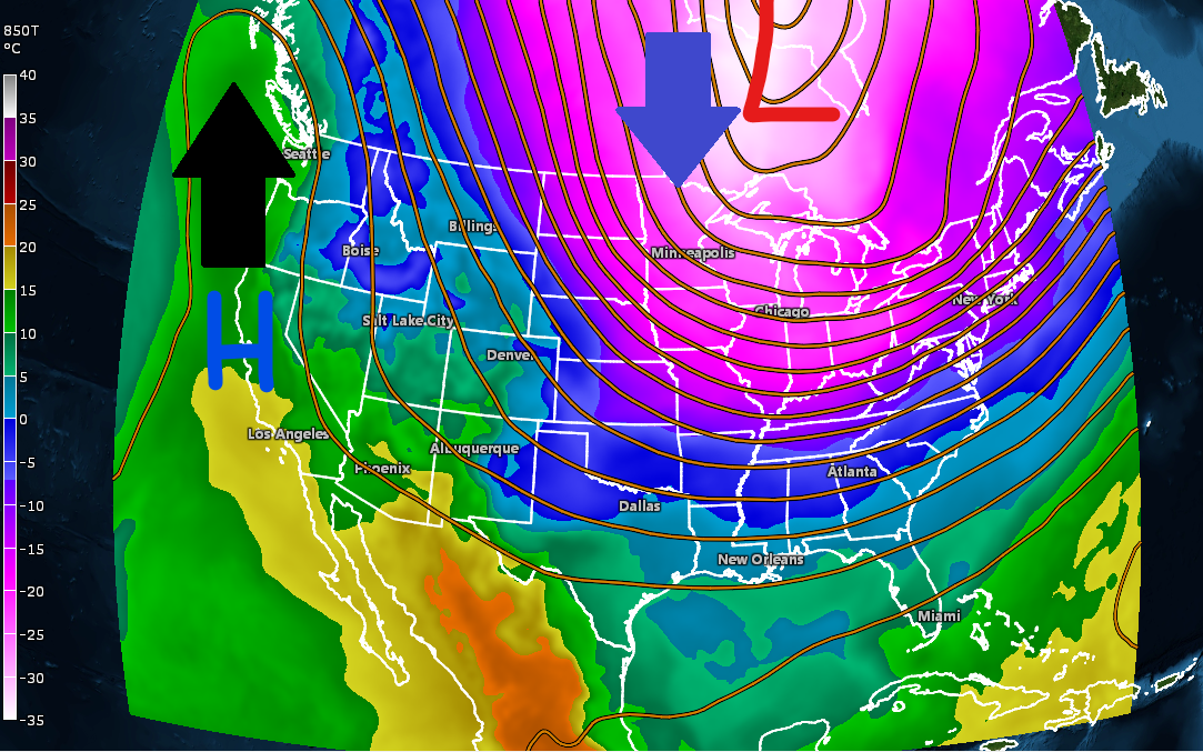
A large ridge is pushing north into Alaska today, while a deep trough develops farther east, letting plenty of Arctic air spill south into the Northland.
It’s going to be frigid tonight, with temperatures dropping into the teens and even 20s below zero. Winds will blow at 5 to 15 mph, with stronger gusts of 15 to 25 mph near Lake Superior, pushing wind chills down to around 30 to 37 below zero.

The next few days will be slightly warmer in our area before the mother lode of arctic air hits us later this week.
Tuesday’s highs will be between 0 and 10 degrees above zero, while Wednesday’s will range from the single digits to the teens above zero.
A chunk of the polar vortex will move in on Thursday, bringing the coldest air of the winter to our area. Highs that day are expected to range from about 10 below to zero, with even colder weather on Friday and Saturday, when high temperatures will mostly stay in the teens below zero across the Northland.
Today, a piece of the polar vortex is sitting over Hudson Bay, Canada, but by Tuesday morning, another part will form farther northwest. This secondary low will move south-southeast, passing north of us on Thursday, when it will also merge with the first mid-level low over Ontario.


From Thursday night through Saturday night, lows are expected to range from 20 to 30 degrees below zero, with some northern areas potentially dipping into the -40s, especially on Friday and Saturday nights.
Wind will be a concern later in the week, and with temperatures as cold as forecasted, it won’t take much for wind chills to plummet to dangerously low levels—possibly hitting the -40s or even -50s in northeast Minnesota and northwest Wisconsin late Thursday night into Friday morning, and again Friday night into Saturday morning.
Note: Much of the Northland will likely need Extreme Cold Warnings later this week.

Snow is expected late Tuesday and Wednesday, with the heaviest amounts of about 1 to 2 inches likely in southern Minnesota. Here in northeast Minnesota and northwest Wisconsin, less than an inch is forecast.

NAM 3km model simulated radar forecast valid 12 PM Tuesday to 12 PM Wednesday.

On Monday morning, several spots in northern Minnesota saw frigid temperatures around -20 or colder, with some of the chilliest readings hitting -22 at Ash Lake, -21 at International Falls, and -20 at Littlefork, Orr, and Cook.
Duluth hit a frigid -17 degrees on Monday morning, making it the coldest day of the winter so far. This beats the previous low of -16 degrees recorded on December 13 and 14.

Bitterly cold wind chills were also present this morning, ranging from around -25 to -40 degrees.
At 7 a.m. today, the wind chill at the Duluth Airport dropped to a frigid -38 degrees.

With all the arctic air moving in this week, there should be much more ice covering Lake Superior by this time next week.
As of January 18, 2026, less than 10% of Lake Superior was covered in ice, while overall Great Lakes ice coverage stood at 16.5%.


With all that open water, lake-effect clouds and snowfall are still widespread over Lake Superior today, affecting parts of the South Shore in northern Wisconsin and Upper Michigan.
Goes-19 visible satellite loop ending 3:21 PM CT Monday, January 19, 2026.

Leave a Reply