Note: The high in Duluth reached 13 degrees today (Wednesday, January 21, 2026), and it’s unlikely we’ll see temperatures that warm again for at least the next week.
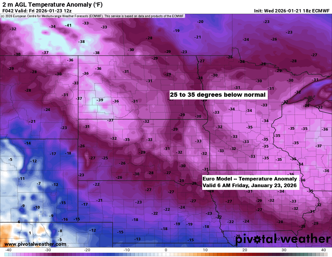
In late January, typical highs in northeast Minnesota and northwest Wisconsin range from the mid-teens to low 20s, with normal lows between about 5 below and 5 above zero. This approaching arctic blast will drop temperatures a staggering 25 to 35 degrees below average over the next few days.
This afternoon, a piece of the polar vortex is sliding south-southeast into northeast Manitoba, bringing with it -40°C temperatures at 850mb near the center of the mid-level low. At the same time, 500mb heights are hitting an impressive 487 decameters, both pointing to an exceptionally cold air mass.
This mid-level low will pass just north of Minnesota on Thursday, bringing with it frigid conditions, with 850mb temperatures across the Northland expected to drop to around -33 to -38°C, with a slight chance of reaching -40°C early Thursday evening.
Tonight’s temperatures will range from about 20 below to 5 below, with the coldest conditions expected in northern Minnesota.
Thursday’s highs will hover around zero to the teens below, while Thursday night’s lows will plunge into the 20s and 30s below zero.
On Friday, highs in the Northland will range from around 8 below to 16 below, with lows Friday night and again Saturday night plunging into the 20s and 30s below zero.
Note: Some areas up north could see temperatures drop to the -40s, especially on Friday and Saturday nights.
…Lowest temperatures so far this winter…
Brainerd, MN: -26 on December 14
Hibbing, MN: -23 on December 14
International Falls, MN: -23 on December 14 and 19
Duluth, MN: -17 on January 19
Ashland, WI: -14 on January 20
Here’s a look at the cold temperature records for Friday.
Most of the coldest high records should hold, but Hibbing’s record seems likely to be broken.
…Record Cold Highs for January 23…
- International Falls: -20 set in 1897
- Duluth: -18 set in 1935
- Ashland: -16 set in 1935
- Brainerd: -16 set in 1963
- Hibbing: -7 set in 1987
…Record Lows for January 23…
- Brainerd: -42 set in 1935
- International Falls: -38 set in 1948
- Ashland: -38 set in 1935
- Duluth: -38 set in 1935
- Hibbing: -37 set in 1996
Analysis from late Wednesday afternoon.

…Gusty Winds…
Northwest winds between 10 and 20 mph, with gusts exceeding 30 mph, are expected tonight through early Friday morning.
The winds are expected to be lighter this weekend.
Euro model wind gust forecast through 6 PM Friday.

…Cold Weather Alerts…
Northeast Minnesota and northwest Wisconsin are under an extreme cold warning from Thursday afternoon through Friday morning, with wind chills expected to range from -45 to -55 degrees.

An extreme cold watch is in effect for all of northeast Minnesota and northwest Wisconsin from Friday morning through Saturday morning, with wind chills expected to range from -40 to -45 degrees.

And finally, there’s a cold weather advisory in effect from midnight tonight until 3 PM Thursday for parts of the Northland, highlighted in light blue, with wind chills expected to drop as low as -40 degrees.

…Winter 2025-2026 Trends…
This winter has brought persistent ridging in the West and a trough in the East, leading to warmer-than-average conditions out west, especially across parts of the Rockies shown in pink and red on the map. Meanwhile, areas from the upper Midwest to the eastern U.S. have experienced colder weather overall, with a few warmer spells sprinkled in.

This winter’s steady northwest flow has brought near to below-average snowfall across the upper Midwest, while areas out west under the ridge have seen snowfall well below average.
Downwind of the Great Lakes, snowfall has been well above average due to a persistent pattern of northwest and westerly winds, along with minimal ice coverage, but that’s about to change in a big way very soon.

There’s very little chance of any change in the weather pattern for the rest of January, so it’s unlikely we’ll see much snow in northeast Minnesota or northwest Wisconsin, including Duluth.
Out of the 20 GEFS ensemble members, only 3 are predicting 2 or more inches of snow for the rest of this month, while the other 17 expect less than 2 inches.

Leave a Reply