After a short break from the active weather pattern, it appears set to return over the next two weeks, with multiple systems potentially impacting the Northland and bringing a chance for significant precipitation.
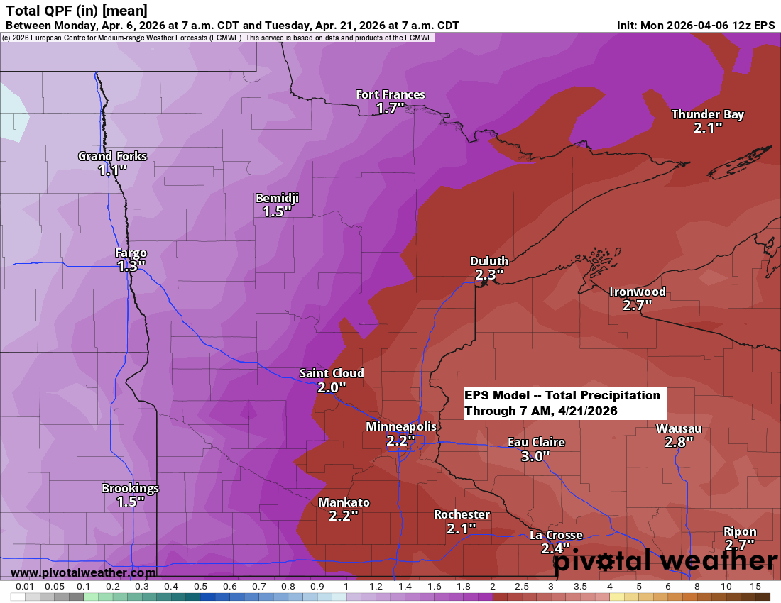
Ensemble models are predicting over 2 inches of precipitation in northeast Minnesota and northwest Wisconsin through April 21st.
As the month progresses, the likelihood of seeing more rain than snow in our area increases, but that doesn’t mean all the precipitation will be rain. There’s still a chance for some wintry mix, especially with a system expected early next week around April 13-14. Definitely something to watch over the next few days.
Note: This month, Duluth has received 0.94 inches of precipitation, which is 0.52 inches above normal. The year-to-date total is 4.30 inches, also 0.46 inches above normal. Overall, we’re doing pretty well with precipitation this year.


…Cold tonight…
A chilly night lies ahead, with mostly clear skies and calming winds as high pressure moves in. Temperatures are expected to dip to the single digits below zero to around 10 above in northeast Minnesota and northwest Wisconsin, with near-record cold possible in some spots by Tuesday morning.
Record Low Temperatures for April 7
International Falls, MN: -9 set in 1982
Hibbing, MN: -2 set in 2023
Brainerd, MN: 0 set in 1936
Ashland, WI: 1 set in 1982
Duluth, MN: 2 set in 1936

…Midweek system…
Northeast Minnesota and northwest Wisconsin are expected to see around 0.1 to 0.25 inches of rain on Wednesday, with smaller amounts likely near the Brainerd Lakes area.

Most of the snow from Wednesday’s system will likely remain over Ontario, but far northern Minnesota and the Arrowhead could get an inch or less of slushy accumulation.
Note: I’m not expecting any snow in Duluth on Wednesday.

…Early April Pattern…
The first few days of April have brought a weather pattern featuring western troughing and ridging across the southern and eastern U.S. This has led to cooler temperatures in the north and much warmer conditions from the south to the east.
Looking ahead, there doesn’t seem to be much change in the overall pattern for the next few weeks, though a few brief shifts may still happen.
In northeast Minnesota and northwest Wisconsin, the average monthly temperatures for April 2026 through the 5th are running between 2 and nearly 7 degrees below normal.

Leave a Reply