Rain is on the way, but it’s still a bit in the distance.
Tonight and Sunday morning will be mostly dry in the Northland, but showers may start Sunday afternoon with increasing rain chances Sunday night, continuing into Monday and Tuesday morning.
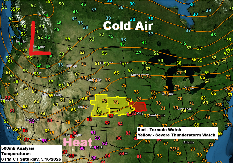
Some elevated instability is expected Sunday and Monday, likely bringing a few thunderstorms to parts of the Northland. There is a low risk of hail and gusty winds, mainly in northwest Wisconsin and eastern Minnesota Sunday night. However, widespread severe weather, including tornadoes, is not expected in our area with this system.
Around Lake Superior, including Duluth, Sunday will bring much colder temperatures, with highs only in the mid-30s to 40s. Strong northeasterly winds will also blow through, with gusts between 25 and 45 mph expected through Sunday and into the night.
The basic setup involves a deep trough over the Rockies that will shift upper-level winds to the southwest in the upper Midwest for the next few days. A couple of low-pressure systems are expected to move northeast from the Plains through Tuesday. Cold air to the north and warmer air to the south will create a zone for heavy rain and thunderstorms between these two air masses. The severe thunderstorm threat is mainly expected to remain south of the Northland on Sunday and Monday.
Rainfall anomalies for May 2026 up to the 16th
- Duluth, MN: -1.56″
- Ashland, WI: -1.55″
- Brainerd, MN: -1.50″
- Hibbing, MN: -1.12″
- International Falls, MN: -1.07″
Note: Rainfall in Duluth is expected to be about 0.10 inches or less by 7 PM on Sunday.

Rainfall totals have dropped a bit with this incoming system, but we’re still looking at widespread amounts of around 1 to 2 inches across northeast Minnesota and northwest Wisconsin, including the Arrowhead and North Shore regions.
Rainfall in northern Minnesota might come in a bit lower, with totals hovering around half an inch or a little more.

NAM 3km model simulated radar forecast valid 7 AM Sunday to 7 AM Monday.

***FLANDERS FIRE***
Flanders Fire started on May 16 near Crosby, Minnesota, affecting 600 acres and was 0% contained.
-County Road 11 is closed between Cross Lake, Minnesota, and State Highway 6 as of 5:32 PM on Saturday, May 16.
-Fire crews and police are evacuating areas east of Horseshoe Lake Road and south of County Road 11 (5:15 PM, May 16).
This afternoon, the smoke plume from the Flanders fire was clearly visible on radar imagery, highlighted by the yellow outlined area on the map.

7:55 PM Saturday — Evacuation map for the city of Cross Lake, Minnesota


…STEWART TRAIL FIRE, NORTHEAST OF TWO HARBORS, MN
As of late Saturday afternoon, May 16, 2026, the fire is 30% contained and has burned 354.6 acres.
Red zones, go
Yellow zones, ready

The past few days have brought active fire weather conditions to the Northland, starting with warm, windy, and very dry weather on Friday, then continuing today with another round of wind and dryness, though temperatures have cooled, especially in northern Minnesota.

Patchy frost is possible early Sunday morning across northern Minnesota and the Arrowhead, with the highest chances north of Duluth.

Leave a Reply