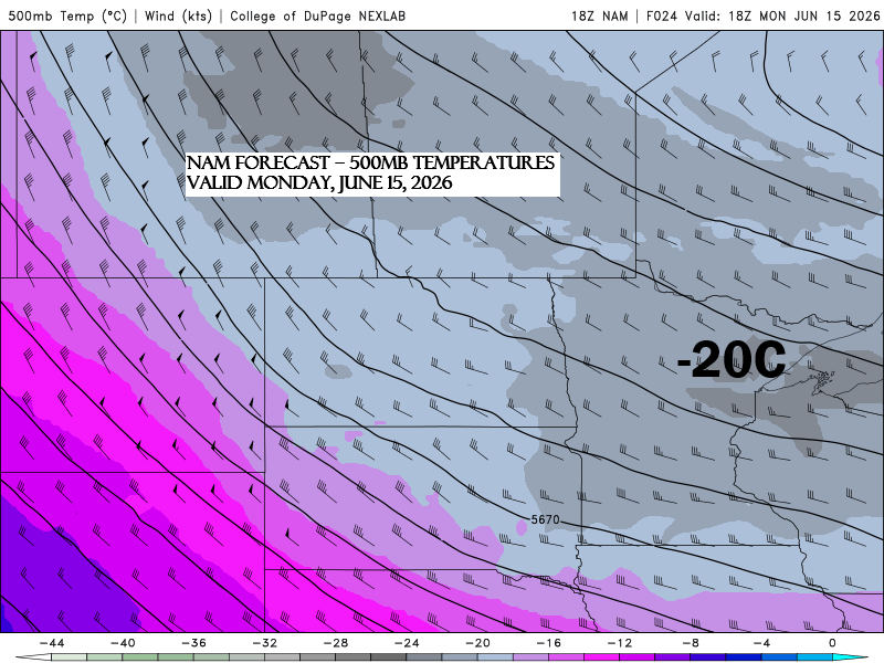
Cold air aloft and warmer surface air, along with a NW flow aloft and a surface trough, will likely lead to scattered showers and a few thunderstorms in the Northland on Monday.
Sufficient CAPE and steep mid-level lapse rates may support some storms, particularly in the afternoon to early evening, with gusty winds of 30-45 mph and hail under 0.75″ expected, though widespread strong to severe storms are not anticipated.
Note: The chance of scattered showers in Duluth will be highest on Monday afternoon, particularly later in the day.
Here’s the NAM 3km model simulated radar forecast valid 12 PM to 11 PM Monday.
It looks like scattered areas in northeast Minnesota and northwest Wisconsin could see around 0.05 to 0.25 inches of rain on Monday.

It’s been pretty windy in the Northland over the past few days.
In Duluth, peak wind gusts of 30 mph or higher were recorded for four days in a row, hitting 34 mph on June 11, 41 mph on June 12, 36 mph on June 13, and 40 mph on June 14.
If you enjoy the blog and want to support it, your generosity truly means a lot.
Make a one-time donation
Make a monthly donation
Make a yearly donation
Choose an amount
Or enter a custom amount
Your contribution is appreciated.
Your contribution is appreciated.
Your contribution is appreciated.
…Midweek rainy system…
For mid-June, this is quite a system (assuming the guidance holds over the next few days), with a strong low near 985mb, or about 29.09 inches, tracking east-southeast out of central Minnesota on Wednesday. If it comes far enough north, it could bring a widespread soaking rain to much of northeast Minnesota and northwest Wisconsin, with totals of half an inch or more, especially in east-central Minnesota and across all of northwest Wisconsin, based on current projections.
Worth noting is the potential for strong northeast winds near Lake Superior on Wednesday, with gusts possibly reaching 20 to 35 mph.

…Temperatures…
This afternoon, temperatures across the region hovered in the mid-60s to low 70s, making for pleasant weather despite the gusty winds. However, these readings are still about 5 to 10 degrees cooler than what’s typical for mid-June.

Highs on Monday will mostly range from the upper 60s to mid-70s in northeast Minnesota and northwest Wisconsin, which is pretty typical for mid-June.
Looking ahead to midweek, cooler weather is on the way, and some parts of the Northland may have trouble climbing out of the 50s on Wednesday.
Duluth has had only one day at or above 80 degrees this month, hitting exactly 80 on June 3rd. On average, the city sees about five such days in June, but it’s unlikely we’ll see any more 80-degree days this week.

Leave a Reply