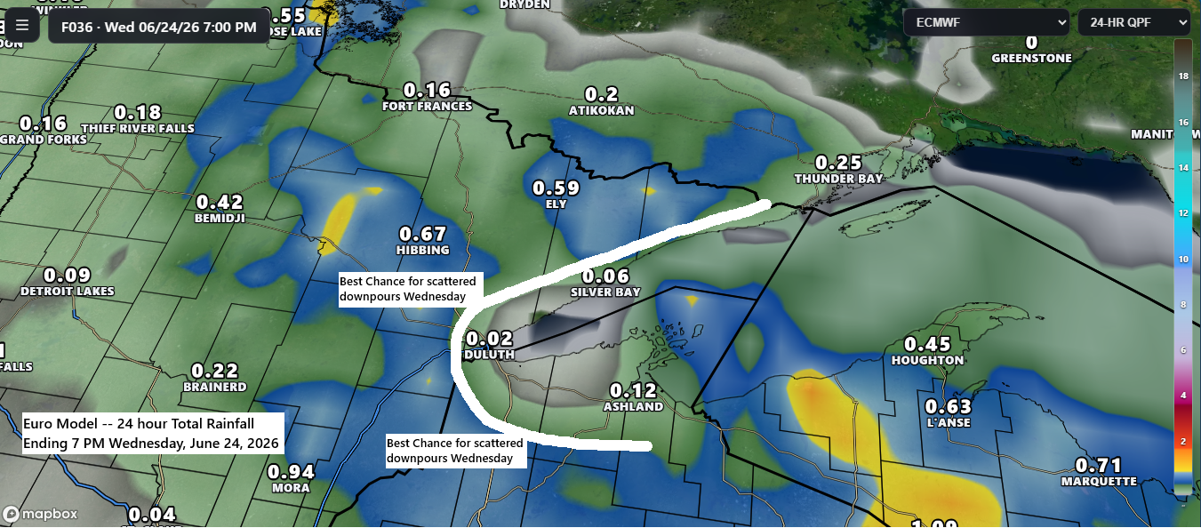
Scattered showers and a few thunderstorms will stick around parts of the Northland on Wednesday, but most of the rain will likely set up inland from Lake Superior. Areas within about 15–20 miles of the lake might just get a brief passing shower, while farther inland could see scattered heavy downpours from time to time.
NAM 3km model simulated radar forecast valid 8 AM to 7 PM Wednesday.
Today’s rain mainly affected the western and southern parts of the Northland, with totals ranging from 0.10 inches to over 0.25 inches, and areas near Brainerd seeing 0.30 inches or more. As the rain moved east, it encountered less favorable conditions, causing it to diminish to just sprinkles by the time it reached the Twin Ports. Overall, the Euro model proved more accurate, predicting much less rain than the other models for today.
Rainfall Totals for June 23, 2026, as of 5 PM
- Pine River, MN: 0.38″
- Brainerd, MN: 0.33″
- Walker, MN: 0.31″
- Grantsburg, WI: 0.30″
- Cass Lake, MN: 0.28″
- Hinckley, MN: 0.28″
- Danbury, WI: 0.23″
- Hill City, MN: 0.23″
- McGregor, MN: 0.22″
- Willow River, MN: 0.19″
- Siren, WI: 0.18″
- Northome, MN: 0.13″
- Grand Rapids, MN: 0.11″
- Spooner, WI: 0.10″
- Floodwood, MN: 0.08″
- Saginaw, MN: 0.02″
- Esko, MN: 0.02″
- Poplar, WI: 0.01″
- Pleasant Valley, MN: 0.01″
- Bigfork, MN: 0.01″
Radar loop ends 6:16 PM Tuesday, June 23, 2026.
…Setup for June 23, 2026…
Today, a low-pressure system moved into eastern North Dakota, bringing along its various frontal boundaries, including an occluded front (purple), a warm front (red), and a cold front (blue), all pushing into the upper Midwest.
This system will drift slowly southeast through Wednesday, bringing occasional scattered showers to northeast Minnesota and northwest Wisconsin. A few thunderstorms may pop up, but widespread strong or severe storms aren’t expected in the Northland.

A jet streak of up to 90 knots is cruising east from the northern Plains today, boosting divergence to the north and southeast along its path.

Stronger mid-level winds southwest of the mid and upper-level low over the northern Plains have pushed far enough east to increase wind shear across western Minnesota, helping to spark a few severe thunderstorms this evening.

Quite a strong system for late June.
Goes-19 water vapor loop ending 6 PM CT Tuesday, June 23, 2026.

Leave a Reply