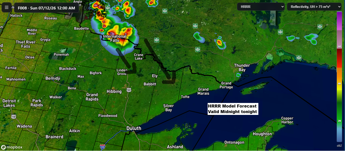
While chances are low, some model runs today suggest showers and thunderstorms could form over far northern Minnesota or southern Ontario tonight. If they do develop, they’d likely track southeast early Sunday morning. There’s plenty of instability and moisture in the air to support storms but rising heights from a ridge building northeast into the area might keep them from moving through overnight. The odds aren’t zero, just on the low side.
HRRR model simulated radar forecast through 10 AM Sunday.
A mid and upper-level ridge over the Rockies is set to expand northeast and strengthen as it moves across the northern Plains and upper Midwest in the coming days. Forecasts show 500mb heights reaching between 597 and 600 decameters on Monday, which is quite remarkable and could be record-setting for this far north.

The heat risk forecast for Sunday indicates that nearly all of northeast Minnesota and northwest Wisconsin will be in a major (red) risk zone.

On Monday, the heat risk stays in the major (red) category, with a few spots reaching the extreme (purple) level.


…Highs on Saturday 7/11…
This afternoon, a few spots in far northern Minnesota hit 90 degrees or a bit higher, with Ashland, WI also reaching 90. In the coming days, 90+ degree heat is expected to be more widespread, and there’s still a chance that some towns could get close to 100 degrees on Sunday and Monday afternoons.
International Falls, Minnesota hit 90 degrees today, July 11th, marking the first time it’s reached 90 or higher since May 29th, when the high was 91 degrees.

In the Twin Ports today, highs climbed into the upper 80s, hitting 89 at Superior Airport and 88 at Duluth Airport. Closer to Lake Superior, it was a bit cooler, with Duluth Sky Harbor Airport topping out at 77.
Highs in the Twin Ports are expected to reach between 91 and 97 degrees on Sunday and Monday, possibly carrying into Tuesday. With strong southwest winds keeping the east wind at bay, no cooling from the lake is anticipated.
The last time Duluth officially hit 90 degrees or higher was on August 26, 2024, with a high of exactly 90 degrees.

Dew points in much of the Northland were in the 60s to low 70s today, making it feel noticeably muggy. Whenever the dew point rises above 60-65 degrees, the air starts to feel humid, and once it tops 70, it becomes downright oppressive.
Over the next few days, dew points will range from the 60s to low 70s, but some areas of the Northland could see them drop into the 50s in the afternoons. This is most likely in far northern Minnesota, where the hottest temperatures are expected.

No new record highs were reached at the main climate stations across the Northland today, July 11. On Sunday, July 12, International Falls and Hibbing will likely have the best shot at tying or breaking a daily record high temperature.
…Record highs for July 12…
Ashland, WI: 105 set in 1936
Brainerd, MN: 103 set in 1936
Duluth, MN: 102 set in 1936
International Falls, MN: 96 set in 1921
Hibbing, MN: 91 set in 1969
Leave a Reply