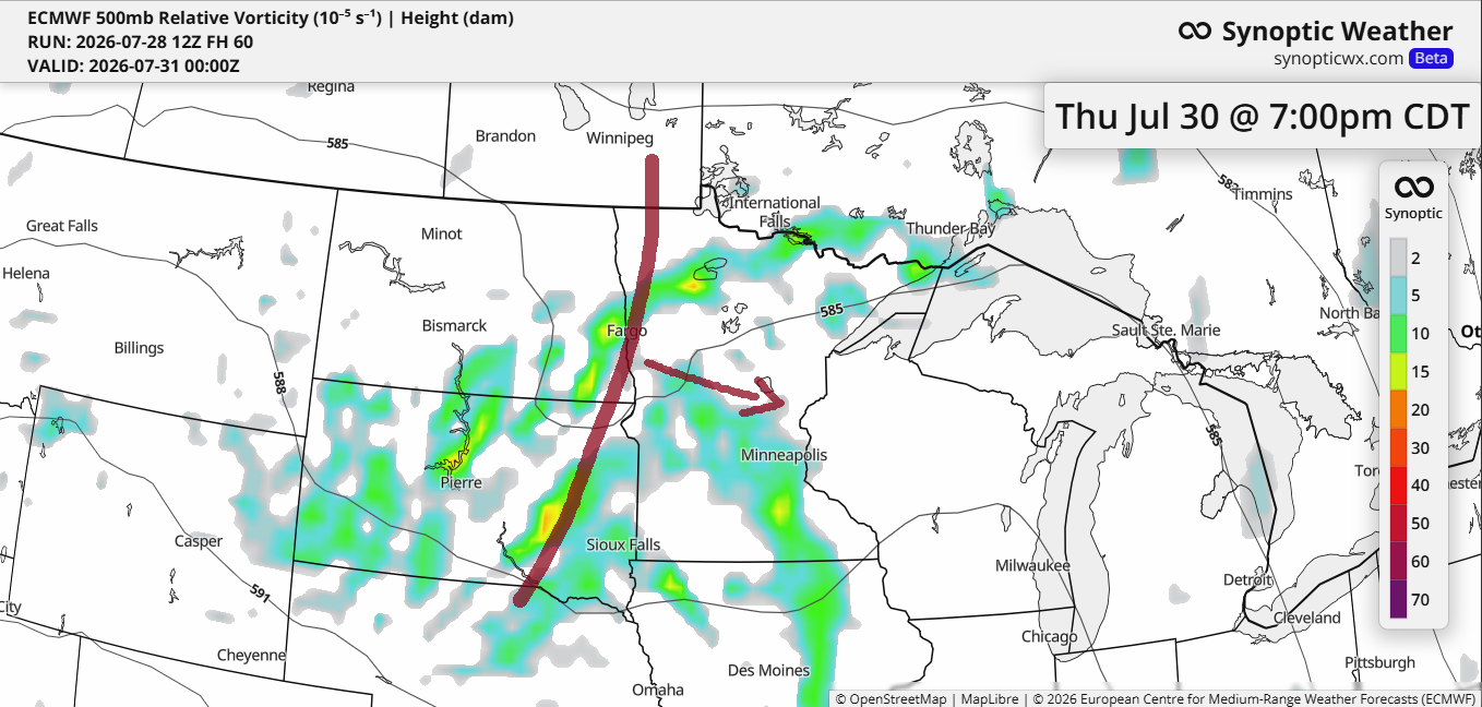
From Thursday to Friday, a trough will slide southeast from the northern Plains, picking up a bit of strength along the way. With ample lift and moisture, it should bring some rain to much of the upper Midwest from Thursday into Friday. Scattered thunderstorms are likely given the instability, but severe storms seem less likely as upper-level winds weaken toward the week’s end and mid-level lapse rates remain unimpressive.
Later in the week, the Northland appears to sit on the northern edge of the system, which could mean slightly less rain than areas farther south. Still, it seems most of the region will get at least some rainfall during that period.
Rainfall anomalies for July 2026, recorded up to 4 PM on the 28th.
- Brainerd, MN: -2.79″
- Ashland, WI: -1.46″
- Duluth, MN: -1.32″
- International Falls, MN: -1.12″
- Hibbing, MN: -0.57″
Precipitable water of about 1.50 to 1.80 inches is expected in northeast Minnesota and northwest Wisconsin from Thursday into Friday, which could bring some heavy rainfall to parts of the region. Farther south, PWATs over 2 inches are forecast, raising the chances for heavier rain there.

The latest forecast from the NWS blend of models is forecasting over 0.75 inches of rain in Duluth by 7 PM Friday with an inch or more possible to the west and south. Lesser amounts of rain are forecast in far northern Minnesota into the Arrowhead.
In the Duluth area, most of the rain will likely fall between Thursday afternoon or evening and into Friday.

Make a one-time donation
Make a monthly donation
Make a yearly donation
Choose an amount
Or enter a custom amount
Thanks for supporting the blog. It truly helps
Your contribution is appreciated.
Your contribution is appreciated.
Flash flooding could occur in some areas between Thursday and Friday, particularly in the yellow-highlighted regions shown on the maps below.
Forecast for Thursday, 7/30/2026

Forecast for Friday, 7/31/2026

This afternoon, inland areas from Lake Superior saw temperatures climb into the 80s, while spots closer to the lake saw highs in the 70s.
This afternoon, dew points across the Northland were mostly in the 60s, reaching up to 70 degrees in some western areas, while in the Arrowhead and near Lake Superior, they ranged from the mid to upper 50s.

On Wednesday afternoon, heat risk levels in the Northland will climb to major (red) and moderate (orange), while areas near Lake Superior, especially along the North Shore, will face only minor heat risks.
Wednesday’s highs are expected to reach the 80s and 90s in northeast Minnesota and northwest Wisconsin, with cooler temperatures near Lake Superior. Dew points will range from the 60s to the low 70s.
It looks like none of the record highs listed are expected to be broken on Wednesday.
…Record Highs for July 29th…
Ashland, WI: 100 set in 1916 and 1988
International Falls, MN: 98 set in 1916 and 1975
Brainerd, MN: 97 set in 1916 and 1947
Duluth, MN: 96 set in 1916
Hibbing, MN: 94 set in 1975


Leave a Reply