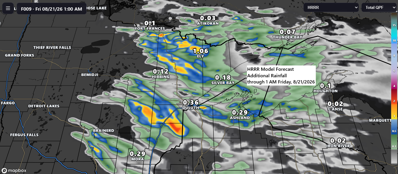
Scattered showers and thunderstorms are forecast to continue across the Northland through this evening, progressing southeastward. These storms may produce brief periods of heavy rainfall, with isolated strong to severe thunderstorms possible. The primary hazards include hail up to half-dollar size (1.25″ in diameter) and wind gusts approaching 60 mph.
The threat of storms is expected to subside overnight.
Rainfall this evening will be highly variable due to convective activity, with some areas receiving little to no rain, while others could see half an inch to an inch or more in a short time.
Radar loop ends 6:10 PM Thursday, August 20, 2026.
Note: A secondary cold front is expected to move southeast across the Northland Friday afternoon and evening, possibly generating isolated showers or thunderstorms, though coverage is anticipated to be less extensive than that of today’s system.
Temperatures ahead of today’s system ranged mostly from the 60s to 70s across northeast Minnesota and northwest Wisconsin, while behind the system, it warmed up, reaching the 80s, with Fargo, ND, peaking near 90 degrees at 89 late this afternoon.

Dew point temperatures rose into the low to mid-60s across much of the Northland this afternoon, with precipitable water levels around 1.2 to 1.4 inches, providing ample moisture to support brief, heavy downpours where storms develop this evening.

The instability axis is relatively narrow this afternoon, with the highest values concentrated within the black-outlined area on the map below. This indicates that storms developing over north-central Minnesota late this afternoon may have difficulty sustaining their intensity as they move southeast into the evening.
This afternoon, mid-level lapse rates are relatively weak—mostly under 6.5 °C/km—which may limit the severity of storms this evening. However, the 0-3 km lapse rates are stronger, generally around 7-8 °C/km, which could allow stronger winds to mix down to the surface if storms sustain themselves and develop cold pools to enhance gusts.

Goes-19 visible satellite loop from Thursday, August 20, 2026, loop time ends 5:30 PM CT.
A well-defined, potent system is progressing through the Northland this evening, with pronounced cyclonic rotation observed across northern Minnesota in this afternoon’s water vapor imagery.
Goes-19 water vapor loop ending 5:30 PM CT Thursday, August 20, 2026.

Estimated rainfall totals for Thursday, August 20, 2026, based on MRMS data.

Actual rainfall totals for August 20, 2026, recorded as of 5 PM.

Rainfall Reports for August 20, 2026, as of 5 PM
- Pine River, MN: 0.44″
- Ely, MN: 0.40″
- Hill City, MN: 0.34″
- International Falls, MN: 0.34″
- McGregor, MN: 0.33″
- Brainerd, MN: 0.28″
- Isabella, MN: 0.28″
- French River, MN: 0.26″
- Willow River, MN: 0.26″
- Hinckley, MN: 0.21″
- Floodwood, MN: 0.20″
- Grand Marais, MN: 0.18″
- Beaver Bay, MN: 0.18″
- Grand Rapids, MN: 0.17″
- Babbitt, MN: 0.16″
- Burnett, MN: 0.16″
- Schroeder, MN: 0.15″
- Pleasant Valley, MN: 0.15″
- Bigfork, MN: 0.15″
- Hog Creek, MN: 0.15″
- Grantsburg, WI: 0.15″
- Littlefork, MN: 0.14″
- Hermantown, MN: 0.13″
- Meadowlands, MN: 0.13″
- Saginaw, MN: 0.13″
- Danbury, WI: 0.12″
- Palmers, MN: 0.12″
- Duluth Airport: 0.11″
- Orr, MN: 0.10″
- Winton, MN: 0.09″
- Eveleth, MN: 0.07″
- Seagull Lake, MN: 0.07″
- Poplar, WI: 0.07″
- Spooner, WI: 0.06″
- Hibbing, MN: 0.06″
- Moose Lake, MN: 0.06″
- Tower, MN: 0.06″
- Aurora, MN: 0.05″
- Siren, WI: 0.05″
- Duluth Sky Harbor Airport: 0.04″
- Buyck, MN: 0.04″
- Northome, MN: 0.04″
- Meander, MN: 0.03″
- Maple, WI: 0.03″
- Ashland, WI: 0.03″
- Odanah, WI: 0.02″
- Minong, WI: 0.02″
- Cook, MN: 0.01″
- Hayward, WI: 0.01″
Leave a Reply