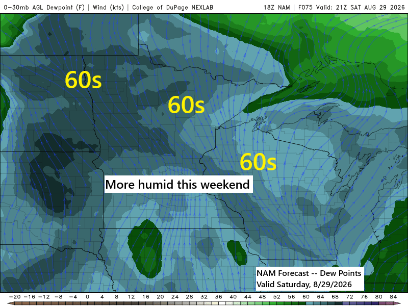
A pattern change could occur this weekend into next week, potentially bringing more persistent southwesterly winds aloft across the Upper Midwest. This is notable, as much of the summer has been dominated by a generally northwest flow aloft.
It remains uncertain whether this will result in a wetter pattern for the Northland. There is a possibility of occasional showers and thunderstorms this weekend and into next week, though it is unclear if these will develop into widespread rain events.
Expect increasingly humid conditions this weekend, with dew points rising into the 60s across the Northland.

The surface setup for this weekend and early next week is quite complex, with multiple lows and surface boundaries forecast across the region. These features should provide enough atmospheric lift to potentially produce occasional showers and thunderstorms during this period.

If you enjoy my content, please consider supporting my work with a donation below.
Make a one-time donation
Make a monthly donation
Make a yearly donation
Choose an amount
Or enter a custom amount
Your contribution is appreciated.
Your contribution is appreciated.
Your contribution is appreciated.
After Tuesday’s rain in Duluth, let’s take a closer look at the current precipitation anomalies.
Month to date
Total: 1.12″
Departure: -2.00″
Since June 1
Total: 10.09″
Departure: -1.34″
Since January 1
Total: 18.38″
Departure: -2.37″
Here’s an overview of rainfall anomalies across the Northland for summer 2026, updated through 4 PM on August 26.
- Brainerd, MN: -5.48″
- Ashland, WI: -4.08″
- International Falls, MN: -2.03″
- Hibbing, MN: -0.41″
Rain totals for northeast Minnesota and northwest Wisconsin through 7 AM Monday (August 31) are currently quite low, generally around a quarter inch or less. I will continue monitoring the data to see if these amounts rise in the coming days.

Additional Storm Reports from August 25, 2026
7:50 PM: Thunderstorm Wind Damage. 7 WNW Trego, WI (Washburn County). Report of a downed tree in the immediate area.
7:43 PM: Hail 1.50 inch (ping pong ball size). 5 WNW Trego, WI (Washburn County)
7:32 PM: Thunderstorm Wind Damage. 2 W Lampson, WI (Washburn County). Report of a tree down on a road near the intersection of County Highway F and Shady Lane near Lampson.
6:48 PM: Thunderstorm Wind Damage. 1 S Duxbury, MN (Pine County). Report of a large tree fallen on a house. The tree was a big spruce tree, estimated 100 years old, about a foot and a half or potentially larger in diameter. The tree was snapped about 40 ft up from the base. The tree led to damage such that the roof will need to be replaced, and it punctured a skylight on the roof. There were also several trees fallen on the road near the property. The spotter noted that the damage path was about 100 yards and very narrow.
5:20 PM: Thunderstorm Wind Damage. 5 NE Rice Lake, MN (St. Louis County). Report of a tree fallen over a powerline on Jean Duluth Road in the vicinity of Normanna and Lismore.
Leave a Reply