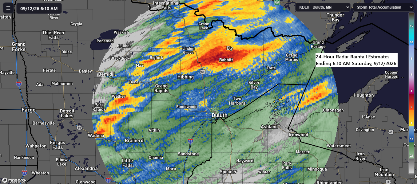
Parts of north-central Minnesota received the heaviest rainfall from Friday’s system, with totals ranging from 1 to 2 inches. In contrast, northwest Wisconsin and far eastern Minnesota saw lighter amounts, generally under a quarter of an inch. Overall, the event closely matched computer model predictions.
Rainfall Report: Friday through Early Saturday Morning, September 11–12, 2026
- Embarrass, MN: 2.27″
- Walker, MN: 2.02″
- Ely, MN: 2.00″
- Babbitt, MN: 1.39″
- Cook, MN: 1.21″
- Side Lake, MN: 1.17″
- Leech Lake, MN: 1.10″
- Bigfork, MN: 1.04″
- Nashwauk, MN: 0.99″
- Meander, MN: 0.81″
- Orr, MN: 0.75″
- Pine River, MN: 0.70″
- Aurora, MN: 0.64″
- Littlefork, MN: 0.60″
- Hermantown, MN: 0.60″
- Hog Creek, MN: 0.59″
- Two Harbors, MN: 0.56″
- Floodwood, MN: 0.55″
- Saginaw, MN: 0.51″
- Meadowlands, MN: 0.50″
- Winton, MN: 0.49″
- Seagull Lake, MN: 0.48″
- Burnett, MN: 0.45″
- Buyck, MN: 0.42″
- Duluth Airport: 0.41″
- Palmers, MN: 0.40″
- Pleasant Valley, MN: 0.40″
- Palisade, MN: 0.39″
- Grand Marais, MN: 0.34″
- Aitkin, MN: 0.34″
- Poplar, WI: 0.33″
- McGregor, MN: 0.32″
- Cass Lake, MN: 0.30″
- Esko, MN: 0.29″
- Willow River, MN: 0.29″
- Keewatin, MN: 0.28″
- Maple, WI: 0.27″
- Brainerd, MN: 0.24″
- International Falls, MN: 0.23″
- Silver Bay, MN: 0.22″
- Schroeder, MN: 0.20″
- Scanlon, MN: 0.20″
- Duluth Sky Harbor Airport: 0.19″
- Hill City, MN: 0.18″
- Hinckley, MN: 0.17″
- Grand Rapids, MN: 0.16″
- Clam Lake, WI: 0.14″
- Solon Springs, WI: 0.13″
- Hayward, WI: 0.12″
- Siren, WI: 0.10″
- Minong, WI: 0.10″
- Glidden, WI: 0.10″
- Winter, WI: 0.09″
- Bayfield, WI: 0.09″
- Danbury, WI: 0.07″
- Ashland, WI: 0.06″
- Moose Lake, MN: 0.05″
- Odanah, WI: 0.04″
- Northome, MN: 0.01″
- Spooner, WI: 0.01″
September 11, 2026: Local Storm Reports
7:29 PM: Thunderstorm Wind Damage. 2 WNW Longville, MN (Cass County). Report of a tree down on a roadway along County Road 5 about 1 to 2 miles west of Longville.
7:19 PM: Thunderstorm Wind Damage. Whipholt, MN (Cass County). Report of a tree down on roadway near Whipholt along the South Shore of Leech Lake.
7:15 PM: Hail 0.50 inch. 5 W Whipholt, MN (Cass County)
4:33 PM: Thunderstorm Wind Damage. 3 E Embarrass, MN (St. Louis County). Tree on powerline.
4:31 PM: Thunderstorm Wind Damage. 2 NNE Embarrass, MN (St. Louis County). Power line down.
4:30 PM: Hail 0.50 inch. 1 NE Embarrass, MN (St. Louis County)
4:27 PM: Thunderstorm Wind Damage. 1 WNW Embarrass, MN (St. Louis County). Tree came down and took out power line and started vegetation fire near a garage.
4:25 PM: Thunderstorm Wind Damage. 2 SW Embarrass, MN (St. Louis County). Report of numerous trees uprooted and snapped on Highway 135 approaching County Road 558 intersection. Most trees are laying towards the northeast though some were laying towards the southeast.
4:22 PM: Thunderstorm Wind Damage. 3 WSW Embarrass, MN (St. Louis County). Several trees blocking the roadway.
4:21 PM: Thunderstorm Wind Damage. 5 WSW Embarrass, MN (St. Louis County). Tree took down power line.
4:14 PM: Thunderstorm Wind Damage. 6 E Britt, MN (St. Louis County). Tree down on powerline resulting in two broken lines.
2:50 PM: Hail 1.00 inch (quarter size). 4 NNW Chisholm, MN (St. Louis County)
Leave a Reply