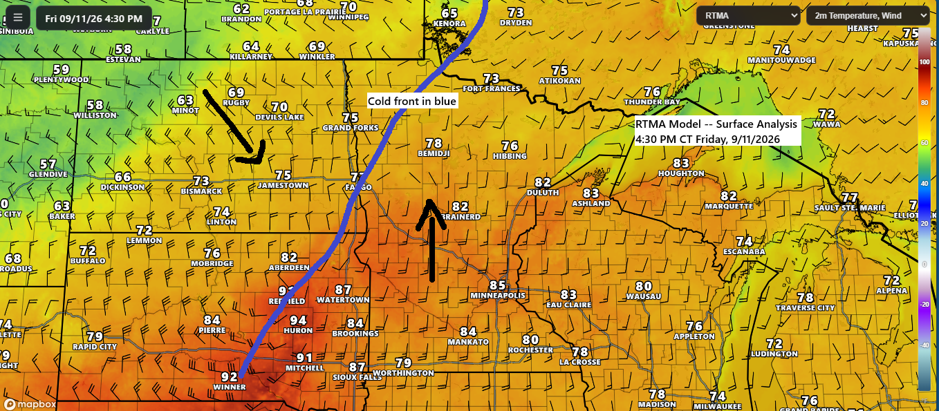
A cold front is moving eastward from northwest Minnesota and the eastern Dakotas this afternoon. Strong southerly winds ahead of the front are bringing warm air and increasing moisture, with temperatures reaching the 70s and low 80s across northeast Minnesota and northwest Wisconsin, and even the 90s in parts of eastern South Dakota. Behind the front, temperatures were mostly in the 60s and 70s across North Dakota, with northwest areas lingering in the 50s.
This weekend, the Northland will experience cooler conditions, with daytime highs predominantly in the 60s. Northwest winds are anticipated to reach up to 30 mph on Saturday, with lighter winds expected on Sunday. Dry weather is forecast throughout the region for both days.
We’ve observed significant rainfall in a localized area of northeast Minnesota this afternoon as thunderstorms repeatedly moved over the same regions. Radar estimates indicate roughly 1 to 2 inches of rain north of a line from Chisholm to Hoyt Lakes and south of a line from near Cook to Ely.

Radar imagery from Friday, September 11, 2026, covering the period from 2:54 PM to 5:53 PM CT.
The morning began with scattered showers and thunderstorms impacting the Twin Ports and sections of the North Shore, bringing brief heavy downpours, followed by additional showers and storms developing across northern Minnesota this afternoon.
Infrared satellite loop from Friday, September 11, 2026, covering 8:00 AM to 5:50 PM CT.
It’s been a breezy Friday, with mild southerly winds prevailing ahead of today’s front, which will shift to the northwest once it passes.

…Tonight’s front…
In the Twin Ports area, showers and thunderstorms are most likely any time after 8 until around 2 AM tonight.
HRRR model simulated radar forecast through 7 AM Saturday.
Additional rainfall totals of 0.5 to over 1 inch are expected tonight across parts of north-central Minnesota, while lighter amounts—ranging from 0.1 to 0.35 inches—are anticipated in the Twin Ports, eastern Minnesota, and northwest Wisconsin.

The highest moisture, with dew points in the 60s, is concentrated in a relatively narrow corridor along and ahead of today’s cold front, while drier air prevails to the east and west of this zone.

The highest potential for severe thunderstorms this evening is in areas with the greatest dew points and CAPE (instability), primarily from west-central to northern Minnesota. Farther east, the parameters for severe weather decrease significantly, resulting in a much lower risk later this evening for eastern Minnesota, including the Twin Ports, and all of northwest Wisconsin.
The primary threats from severe thunderstorms this evening across west central to northern Minnesota include large hail measuring 1 to 2 inches in diameter (about the size of a quarter to a hen’s egg) and damaging wind gusts of 60 to 70 mph.

With significant wind shear in place this evening over west-central and northern Minnesota—including up to 40 knots of bulk shear and 25 knots of 1 km shear, along with effective storm-relative helicity values reaching 200 m²/s²—there is potential for one or two tornadoes in these areas this evening.

Significant moisture transport is occurring ahead of today’s frontal system, as indicated by the green and red areas on the image below. This enhanced moisture influx is expected to produce locally heavy rainfall in areas affected by thunderstorms this evening.

The Northland is currently under warm air advection from today’s system, but this will give way to a cold air advection pattern on Saturday as the system moves eastward.

Leave a Reply